


|
||

|

|
|

|
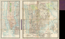
Rare separately published map of Manhattan, published in 1908.
Issued four years after the first New York Subway was opened in 1904, the map shows a remarkable picture of the growth of the subway lines, which now extend north across all of Manhattan in two lines.
A key at the bottom notes:
- Subway Lines and Tunnels completed (solid red line)
- Subway Lines under Construction (broken red line)
- Elevated Railroads (checked line)
- Surface Car Lines (dashed line)
Locates the Brooklyn Bridge, Manhattan Bridge, East River Bridge, Blackwell's Island Bridge, several tunnels across the Hudson and many other details.
Rarity
While the later 1913 Rand McNally Map of Manhattan appears on the market, this 1908 edition is very rare.
Rand McNally & Co. is a large American map and navigation company best known for its annual atlases. The company got its start in 1856, when William Rand opened a print shop in Chicago. He was joined in 1858 by a new employee, Andrew McNally. Together, the men established their namesake company in 1868. Originally, the company was intended to print the tickets and timetables for the trains running to and through Chicago; their first railway guide was published in 1869.
By 1870, they had shifted from just printing to publishing directories, travel guides, and newspapers. Their first map appeared in 1872 in a railway guide. The map was produced using a new wax engraving method, a cheaper process that gave the company an edge.
By 1880 Rand McNally had entered the education market with globes, wall maps, and geography texts for students. In 1923, Rand McNally published the first Goode’s World Atlas, named after its editor, Dr. J. Paul Goode. For generations afterward, this would be the standard classroom atlas.
In 1899, William Rand left the company, but McNally and his family remained, controlling the company for over a century. In 1904, they published their first road map intended for automobiles and by 1907 were publishing Photo-Auto Guides, which combined photography and mapping to help drivers. In 1924, they produced the Auto Chum, a precursor to their famous road atlases. Rand McNally would remain the leader in road maps and atlases throughout the twentieth century.
In 1937, Rand McNally opened its first store in New York City. Ever on the frontier of technology, Rand McNally pioneered the scribing process for printing tickets in 1958 and printed their first full-color road atlas in 1960. Arthur Robinson developed his now-famous projection of Rand McNally in 1969. By the 1980s, the company was exploring digital reproduction and digital databases of maps for truckers. In the 1990s, they lead the charge to develop trip-planning software and websites. Today, most of its products are available online or in a digital format, including maps for tablets and phones.


![(American Revolution) [Manuscript Map of New York City and Northern New Jersey]](https://storage.googleapis.com/raremaps/img/small/69609.jpg)
![[Hells Kitchen / Midtown West] Map of the Hermitage Farm and the Norton Estate Compiled From Authentic Data.](https://storage.googleapis.com/raremaps/img/small/61035.jpg)