|
||

|

|
|

|
Stock# 91378
Description
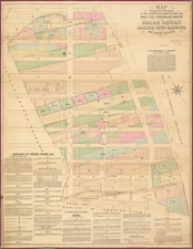
Original antique map of the Long Island City waterfront between Roosevelt Island and Long Island Sound, from Beers's Long Island Atlas, published in 1873.
The map focuses on the communities of Long Island City, Dutch Kills, Ravenswood, and Astoria. It shows street-level detail and also maps individual landowners for larger plots of land. Important buildings, rail connections, hydrography, and other features are indicated. The map is colored by neighborhood.
Large portions of the region remain undeveloped, especially in Bowery Bay. Workhouses, a lunatic asylum, a reservoir, and a penitentiary are shown on Roosevelt Island.
Condition Description
Original hand-color. Slight toning and minor offsetting
![[Bowery / Chinatown / Lower Manhattan] Map of Delancy's Farm Western Part](https://storage.googleapis.com/raremaps/img/small/59560.jpg)
![[Harlem]. Map of the Harlaem Commons surveyed agreeably to the boundaries established by the Commissioners appointed to settle the boundary lines between the common lands of the City of New York and the Town of Harlaem...](https://storage.googleapis.com/raremaps/img/small/59385.jpg)
![[Long Island City - Blackwell's Island Bridge]](https://storage.googleapis.com/raremaps/img/small/59904.jpg)