This item has been sold, but you can enter your email address to be notified if another example becomes available.


|
||

|

|
|

|
Stock# 62867
Description
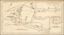
Detailed map of the Lake Wakatipu Region, published by the New Zealand Government Department of Tourist and Health Resorts.
The map identifies:
- Coach & other Main Roads
- Bridle Roads
- Foot Tracks
- Homesteads
- Villages
At the bottom right is a table of distances.
Lake Wakatipu was formed by glaciers more than 15,000 years ago. It was first explored August 1859 by a Scottish surveyor, Donald Hay.
Queenstown was once called “Camptown” and was an important town during the gold rush in the 1800s.
![Isles de Salomon [Early depiction of New Zealand!]](https://storage.googleapis.com/raremaps/img/small/101683.jpg)