|
||

|

|
|

|
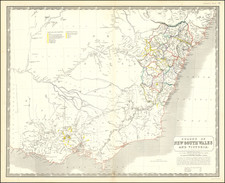
Fine map of Australia, New Zealand and Neighboring Islands, with a large inset of New South Wales and Van Dieman's Land, published by Lizars.
The map offers an in-depth visual portrayal of the known geography in the region, during an era marked by exploration and nascent colonization. In a blend of earthy tones, the regions are demarcated with precision and clarity, reflecting an admirable attention to detail by the Scottish cartographer, Lizars.
Australia is delineated into two major portions: New Holland to the west, and New South Wales to the east. These monikers carry the weight of exploration history. "New Holland," a name given by Dutch explorers during their early 17th century voyages, pays homage to Holland, their homeland. By the 1820s, however, this term was being slowly replaced by "Australia," a name proposed by the British navigator Matthew Flinders in 1804, and officially adopted by the British Admiralty in 1824.
The eastern section, "New South Wales," commemorates the initial British penal colony established in 1788, under the command of Captain Arthur Phillip. This territory originally encompassed the entire eastern half of Australia, as depicted on the map. Additional areas named include South Australia, Australia Felix, and Van Diemen's Land, the latter known today as Tasmania, christened by the Dutch explorer Abel Tasman in honor of Anthony van Diemen, the Governor-General of the Dutch East Indies, in 1642.
The map also refers to historical monikers along the west coast, all bearing Dutch origin. These include Nuyts Land, discovered by Pieter Nuyts in 1627; Lyon's Land, charted by the English explorer Matthew Flinders in the early 19th century; Edels Land, named after the Dutch explorer Jacob d'Edel who sailed along the western coast in 1619; Endrachts Land, christened by Dirk Hartog in 1616 when he arrived on the ship "Eendracht"; De Witt's Land, named after a Dutch governor; and a repetition of Van Diemen's Land, initially believed to be part of the mainland.
A noteworthy feature of the map is the large inset depicting the Colony of New South Wales and Van Diemen's Land in remarkable detail. These insets reflect the bustling activity of the time, the blossoming settlements, towns, and the intricate road networks weaving them together. The first half of the 19th century was a transformative period for Australia. The transportation of British convicts to the penal colonies had bolstered the population, and explorers were pushing the frontiers of the known map, moving further inland into the expansive and largely untouched continent.
By 1825, the year this map was published, the British had established several thriving colonies. Sydney, founded as a penal colony, was gradually transforming into a robust commercial city. Moreover, the discovery of fertile lands in the interior of New South Wales led to an agricultural boom, significantly shaping Australia's development.
However, the map also stands as a poignant testament to the tumultuous history of this region. The cartographer's meticulous annotations elide the impact of these colonial endeavors on the indigenous populations, a sobering reality of this age of discovery and colonization.
The Lizars were a Scottish family of engravers and printers who produced many views and maps. Daniel Lizars Sr. (1754-1812) was the son of a shoemaker, but he apprenticed with Andrew Bell, a printer and engraver. Lizars set up his own printworks near St. Giles Cathedral and took on his own apprentices, including George Bartholomew, whose son John would go on to found the important mapmaking firm later know as John Bartholomew & Son Ltd.
Daniel Sr. had three sons: Daniel Jr., John, and William Home. He also had a daughter, Jane Home. Daniel Jr. (1793-1875), the youngest of the boys, apprenticed in his father’s shop alongside George Bartholomew. When his father died in 1812, Daniel Jr. took over much of the business, expanding it and specializing in maps. The company went bankrupt in 1832, however, and Daniel emigrated to Canada.
John Lizars (1792-1860), the middle son, studied medicine and became Professor of Surgery at the Royal College of Surgeons of Edinburgh, as well as senior surgeon at the Royal Infirmary of Edinburgh.
William Home Lizars (1788-1859), the eldest, also apprenticed in his father’s shop. After learning engraving, William entered the Trustees’ Academy to learn under John Graham. He was a skilled painter and artist. When his father died, and after his Daniel Jr. left, he carried on printing and invented a method of etching that looks like wood engraving.

![Asia [with inset:] New Holland or Australia.](https://storage.googleapis.com/raremaps/img/small/98818.jpg)
![Western Australia containing the Settlements of Swan River and King George's Sound… [with ] Van Diemen Island](https://storage.googleapis.com/raremaps/img/small/99485.jpg)