


|
||

|

|
|

|
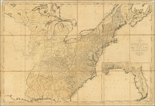
One of the Earliest Wall Maps of the United States Published In America
Scarce separately published example of the Samuel Lewis four-sheet map of the United States, "Engraved for and Sold By Matthew Carey, Philadelphia."
The present example is colored up in original outline color to show the creation of Mississippi Territory, shortly after the Yazoo Land Scandal of 1802 and Missisippi's becoming a Territory in approximately the configuration shown in 1804, and after the creation of Illinois Territory in 1809.
Although the region is still named "Northwest Territory," the map shows the outlines of Ohio (statehood granted on February 19, 1803), Indiana Territory (created May 7, 1800), Illinois Territory, Michigan Territory (created June 30, 1805) and an early illustration of what would become Wisconsin Territory, prior to Illinois statehood (1818), when the future Wisconsin Territory would become part of Michigan Territory.
The area which corresponds to Michigan Territory extends further west than the actual territory, incorporating all of Green Bay and the region to the south. Curiously, the point on which the boundary intersects Lake Superior is relatively accurate to the modern border. It is probable that this mis-configuration relates to the period when Illinois was shown further west with no portion of the Territory touching Lake Michigan, a configuration that appeared on maps from Illinois Territory's formation in 1809 to about 1820.
The map also shows a very definite dashed line beginning north of Mobile Bay and tracking the Tombigbee River and later the Sipsy River, before crossing over to Muscle Shoals.
The Lewis map is one of only 5 multi-sheet maps of the United States printed in America prior to 1800. The other 4 (Abel Buell, Osgood Carleton, Abraham Bradley and William MacMurray) are essentially unobtainable.
The first state of Lewis' map incorporates for the first time on a large format map of the United States the newly created Territory of "Tennasee" (which would become a state on June 1, 1796) and Kentucky (which had become a state on June 1, 1792), along with a reasonable well configured treatment of the District of Maine, which would not become a state until 1820.
East and West Florida are still shown, with only the Missouri River and a few minor tributaries shown west of the Mississippi River.
Mississippi Territory
The United States and Spain disputed these lands east of the Mississippi River until the Treaty of Madrid, initially signed in 1795 by the two countries' representatives. The Mississippi Territory was organized in 1798 from these lands, in an area extending from 31° N latitude to 32°28' North — or approximately the southern half of the present states of Alabama and Mississippi.
Georgia maintained a claim to most of the states of Alabama and Mississippi (from 31° N to 35° N), until it surrendered its claim in 1802 following the Yazoo land scandal. In 1804, Congress extended the boundaries of the Mississippi Territory to include all of the Georgia cession.
Rarity
The Carey United States map is rare on the market. Because it so rarely appears in color, it is very difficult to gage the rarity of this state of the map, but we can confidently say that this is the only example we have seen with outline color which shows these territorial configurations.


![[The Final State] A New Map of North America, with the West India Islands, Divided according to the Preliminary Articles of Peace, Signed at Versailles, 20 Jan. 1783, wherein are Distinguished The United States and the Several Provinces, Governments &c Which Compose the British Dominions . . . 1794](https://storage.googleapis.com/raremaps/img/small/89085.jpg)