|
||

|

|
|

|
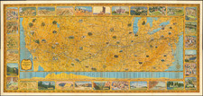
A Fascinating French convolute of Shoshone, Idaho & Montana Territories.
Finely colored large format map of the United States, depicting the evolution of the Western Territories, as they were created in the 1860s.
Includes marvelous ephemeral western territorial borders, including an area labeled and colored as a territory called "Shoshone", recognition of the powerful presence of the Shoshone Indian Tribes in the region during the 1850s and 1860s.
California is oddly shaped, extending to the Colorado border. Arizona is now west of New Mexico, but also oddly configured. Washington Territory extends to the Rocky Mountains, with the southern half of Idaho called Shoshone.
The newly created Idaho Territory is shown running from within the Shoshone region to the Missouri River, taking up much of what would become Wyoming.
Montana Territory delineated, but extends to the Missouri River, taking up a portion of the future Dakota Territory.
Nebraska Territory extends from the Rockies to the Missouri. Texas is oddly configured and the early French, German and Mainzer Colonies in Texas are shown.
Historical Overview of Idaho and Montana Territories:
Idaho Territory was officially organized on March 4, 1863. It is a successor region that was created by areas from existing territories undergoing parallel political transitions beginning with disputes over which country owned the region. By 1863 the area west of the Continental Divide that was formerly part of the huge Oregon Territory, had been divided into Washington Territory north of the young State of Oregon. To the east, the remnant of the Oregon Territory was officially 'unorganized'- whereas most of the area east of the Continental Divide had been part of the loosely defined Dakota Territory ending along the 49th parallel-now the border with Canada, then a colonial possession of Great Britain.
The original newly organized Idaho Territory covered most of the present-day states of Idaho, Montana and Wyoming. It was wholly spanned east-to-west by the bustling Oregon Trail and partly by the other emigrant trails, the California Trail and Mormon Trail.
In 1864, the Montana Territory was organized from the northeastern section of the territory east of the Bitterroot Range. Most of the southeastern area of the territory was made part of the Dakota Territory.
![[The Final State] A New Map of North America, with the West India Islands, Divided according to the Preliminary Articles of Peace, Signed at Versailles, 20 Jan. 1783, wherein are Distinguished The United States and the Several Provinces, Governments &c Which Compose the British Dominions . . . 1794](https://storage.googleapis.com/raremaps/img/small/89085.jpg)
![[ Atlantic Ocean / Triangular Trade / Negroland ]](https://storage.googleapis.com/raremaps/img/small/65187.jpg)