|
||

|

|
|

|
Interesting hand drawn sea chart of the North Atlantic, illustrating the region covered by the Triangular Trade.
The chart focuses on the major trading ports in America (Charleston, Boston, New York, Baltimore and Philadelphia), with a very curious island off the coast of New York.
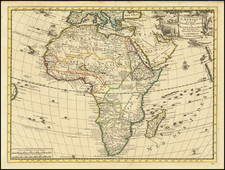
In Africa, the regions located include Negroland, Senegambia and Guinea.
The term Negroland is typically associated with maps issued in the first half of the 18th Century in England and references the largely unexplored regions of West Africa. Similarly, the name Senegambia is quite arcane.
The map is quite unusual -- we surmise that it was created in England or North America in the first part of the 19th Century and may have been done as a school exercise. The maker was quite meticulous, first using a pencil to lay out the major locations and then completing the map with pen and ink.
![[Democratic Republic of the Congo] Congo Belge](https://storage.googleapis.com/raremaps/img/small/77991.jpg)