|
||

|

|
|

|
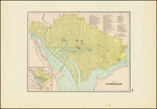
Scarce 1880 update of Boschke's 1861 map of the city and vicinity of Washington, D.C.
Boschke, a draughtsman for the Coastal Survey department surveyed the city at his own expense in the years 1856-59 with an eye to selling the map to the government. Instead he was fired for neglect of official duty with the plates seized by the government. T
This map uses the partial cadastral projection to show the region which includes some householders' names, individual buildings, and vegetation. Relief is shown by contours and hachure. In the Potomac are scores of depth soundings plus contours. The map includes a portion of the Virginia shoreline. This updated edition adds color and a large section at upper left labeled "Available Site for Park & Reservoir."
![Preliminary Chart of the Potomac River (in four sheets) Sheet No. 1 From Entrance to Piney Point [with] Sheet No. 2 From Piney Point to Lower Cedar Point [with] Sheet No. 3 From Lower Cedar Point to Indian Head [with] Sheet No. 4 From indian Head to Little Falls Bridge](https://storage.googleapis.com/raremaps/img/small/88214.jpg)
![[ Lung Disease Epidemiology Map ] Map of Washington and Georgetown](https://storage.googleapis.com/raremaps/img/small/98983.jpg)