|
||

|

|
|

|
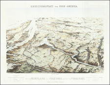
First edition of Bradford's map of the District of Columbia, one of the earliest obtainable maps to show the District.
The map shows the town plans for Washington, Georgetown and Alexandria, along with early roads and the Chesapeake & Ohio Canal and the Baltimore & Washington Railroad.
The District of Columbia was established in 1790 as the capital of the United States. At the time this map was created, in 1835, the city was still relatively small and undeveloped. The population was around 30,000. Bradford's map is a fascinating snapshot of the city at this time in its history. It shows the major streets and landmarks, as well as the boundaries of the city and its surrounding areas.
Thomas Gamaliel Bradford (1802-1887) was an American geographic publisher. He hailed from Bradford, Massachusetts and began his publishing career by working for the America Encyclopedia. Then, he edited and republished the Atlas Designed to Illustrate the Abridgement of Universal Geography, Modern & Ancient, which had originally been offered in French by Adrian Balbi. In 1835, he published another atlas, A Comprehensive Atlas: Geographical, Historical & Commercial, and, in 1838, An Illustrated Atlas Geographical, Statistical and Historical of the United States and Adjacent Countries. His interests were primarily in educational publishing and he was one of the first mapmakers to show Texas as an independent country.
![[ Washington DC ] Plan of the City of Washington in the Territory of Columbia ceded by the States of Virginia and Maryland to the United States of America and by them established as the Seat of their Government after the Year 1800](https://storage.googleapis.com/raremaps/img/small/100759.jpg)

![[ Washington DC / Virginia / Maryland / Delaware / New Jersey ] Washington Sectional Aeronautical Chart](https://storage.googleapis.com/raremaps/img/small/99620.jpg)