


|
||

|

|
|

|
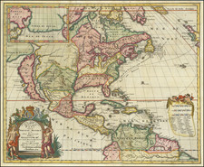
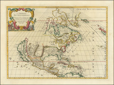
Striking example of Hennepin's map of North America, from his Nouvelle Decouverte d'un Tres Grand Pays. Hennepin, a member of the Recollet Order of Franciscans, accompanied La Salle on his journey down the Mississippi in 1682, in search of a water route to the Pacific. An excellent summary of the state of knowledge at the beginning of the 18th century of the geography of North America. Among other things, this beautiful map attempts to place into perspective Hennepin's mapping of the Great Lakes and the Mississippi River. Karpinski noted that Hennepin's delineations of Lakes Superior, Michigan and Huron are remarkable improvements upon the Sanson maps. The map's configuration of the Great Lakes and of the North American Coastline suggest reliance upon a different map than his more regional map.Both maps, however, show the Mississippi River entering the Gulf far to the west of its actual location. Some historians believe this was done deliberately by La Salle to discourage colonization of the Gulf area by rival nations, by showing the lower Mississippi as Spanish territory. Hennepin was one of the most popular chroniclers of the exploration of the American interior. Several books in numerous editions appeared under his name, although he was also given to sensational and unsupportable claims, such as his claim to have been first to the mouth of the Missisippi, ahead of LaSalle. A seminal collectors map. While the later 1704 edition appears on occasionally on the market, this 1698 edition is quite scarce. Repaired tear on verso, just below Terra Iesso, but still a gorgeous example.

![[ Trans-Atlantic Cable ] Amerique Septentrionale avec l'indication des Principaux Courants marins d'Amerique en Europe](https://storage.googleapis.com/raremaps/img/small/98084.jpg)