|
||

|

|
|

|
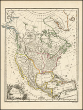
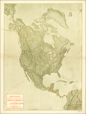
Noting The Completion of the First Successful Trans-Atlantic Cable
Colorful map of North America, published shortly after the completion of the first Trans-Atlantic cable (1866) and the acquisition of Alaska by the United States (1867).
The map's title notes that it shows principal currents of the North Atlantic and North Pacific Oceans, as well as the location of the first underwater transatlantic telegraph cable to England and France.
This is the second state of the map, first issued in about 1868.
Trans-Atlantic Cable
The history of the trans-atlantic cable prior to 1875 is a remarkable chronicle of engineering feats, international collaboration, and the indomitable human spirit in the quest to shrink the communication gap between continents. The successful establishment of a transatlantic telegraph cable in the 19th century was a pivotal moment in global communications, transforming the exchange of information.
The first attempts to lay a cable across the Atlantic were marked by trial and error. The initial endeavor in 1857 ended in failure, but it set the stage for future undertakings. The following year, in 1858, a new effort led to the first successful transmission of messages across the Atlantic. However, this triumph was short-lived, as the cable ceased functioning after just three weeks.
Undeterred, the project's visionaries continued to refine their techniques and technology. In 1865, the Great Eastern, the largest ship of the time, embarked on another cable-laying voyage, which, despite improvements in cable design and laying methods, ended with the cable breaking and being lost to the sea. It was not until the subsequent expedition in 1866 that a fully functional, durable transatlantic cable was finally laid, providing reliable communication between Europe and North America.
The first successful transatlantic telegraph cable connecting France to the United States was completed 3 years later in 1869.
![[Pan American Menu Map] North America](https://storage.googleapis.com/raremaps/img/small/103976.jpg)