|
||

|

|
|

|
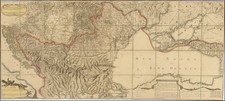
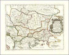
Highly detailed map of Serbia and Bulgaria, published by Petermann.
The new Serbo-Bulgarian, Serbo-Greek, Greco-Bulgarian and Bulgaro-Romanian boundaries are shown as definite, while the Serbo-Montenegrin, Serbo-Albanian and Albano-Montenegrin boundaries are shown as provisional and the new Turco-Bulgarian boundary is not shown at all.
The map illustrates the newly created boundaries at the conclusion of the Balkan Wars.
The Balkan Wars consisted of two conflicts that took place in the Balkan Peninsula in 1912 and 1913. Four Balkan states defeated the Ottoman Empire in the first war; one of the four, Bulgaria, suffered defeat in the second war. The Ottoman Empire lost the bulk of its territory in Europe. Austria-Hungary, although not a combatant, became relatively weaker as a much enlarged Serbia pushed for union of the South Slavic peoples. The war set the stage for the Balkan crisis of 1914 and thus served as a "prelude to the First World War".
By the early 20th century, Bulgaria, Greece, Montenegro and Serbia had achieved independence from the Ottoman Empire, but large elements of their ethnic populations remained under Ottoman rule. In 1912 these countries formed the Balkan League. The First Balkan War had three main causes:
- The Ottoman Empire was unable to reform itself, govern satisfactorily, or deal with the rising ethnic nationalism of its diverse peoples.
- The Great Powers quarreled amongst themselves and failed to ensure that the Ottomans would carry out the needed reforms. This led the Balkan states to impose their own solution.
- Most importantly, the Balkan League had been formed, and its members were confident that it could defeat the Turks.
The Ottoman Empire lost all its European territories to the west of the River Maritsa as a result of the two Balkan Wars, which thus delineated present-day Turkey's western border. A large influx of Turks started to flee into the Ottoman heartland from the lost lands. By 1914, the remaining core region of the Ottoman Empire had experienced a population increase of around 2.5 million because of the flood of immigration from the Balkans.
The event triggered the ultimate collapse of the empire itself within five years. Nazım Pasha, Chief of Staff of the Ottoman Army, was held responsible for the failure and was assassinated on January 23, 1913 during the 1913 Ottoman coup.
The First Balkan War began when the League member states attacked the Ottoman Empire on October 8, 1912 and ended eight months later with the signing of the Treaty of London on May 30, 1913. The Second Balkan War began on June 16, 1913. Both Serbia and Greece, utilizing the argument that the war had been prolonged, repudiated important particulars of the pre-war treaty and retained occupation of all the conquered districts in their possession, which were to be divided according to specific predefined boundaries.
Seeing the treaty as trampled, Bulgaria was dissatisfied over the division of the spoils in Macedonia (made in secret by its former allies, Serbia and Greece) and commenced military action against them. The more numerous combined Serbian and Greek armies repelled the Bulgarian offensive and counter-attacked into Bulgaria from the west and the south. Romania, having taken no part in the conflict, had intact armies to strike with, invaded Bulgaria from the north in violation of a peace treaty between the two states. The Ottoman Empire also attacked Bulgaria and advanced in Thrace regaining Adrianople.
In the resulting Treaty of Bucharest, Bulgaria lost most of the territories it had gained in the First Balkan War in addition to being forced to cede the ex-Ottoman south-third of Dobroudja province to Romania.
August Heinrich Petermann (1822-1878) is a renowned German cartographer of the nineteenth century. Petermann studied cartography at the Geographical Art-School in Potsdam before traveling to Edinburgh to work with Dr. A. Keith Johnston on an English edition of Berghaus’ Physical Atlas. Two years later he moved to London, where he made maps and advised exploratory expeditions as they set off to explore the interior of Africa and the Arctic.
In 1854, Petermann returned to Germany to be Director of the Geographical Institute of Justus Perthes in Gotha. There, he was the editor of the Geographische Mittheilungen and Stieler’s Handatlas. The Royal Geographical Society of London awarded him their Gold Medal in 1860. He continued his interest in exploration in Germany, fundraising for the German Exploring Expeditions of 1868 and 1869-70, which sought an open Arctic sea. Tragically, he committed suicide in 1878.
![[ Ancient Greece & Balkans ] Illyricum, Dacia, Moesia Macedonia et Thracia](https://storage.googleapis.com/raremaps/img/small/102174.jpg)