|
||

|

|
|

|
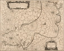
Second state of F.J.M. Maire's extremely rare map illustrating the geographical changes in the region between 1718 and 1788.
This second state is greatly improved, with over 150 new place names added which were not present in the First State.
Issued in 1788, at the beginning of the Russo-Turkish War of 1787-1792, the map provides a fine overview of the theater of war between the major regional empires. Titled in both German and French, the map illustrates the evolving borders among three significant empires—the Ottoman Empire, the Russian Empire, and the Habsburg Monarchy. Specifically, it focuses on regions surrounding the Black Sea, the Balkans, and Hungary, illustrating changes from the year 1718 up to 1788.
The lower cartouche depicts the imperial double-headed eagle and the Russian eagle, which is shown tearing to pieces an Ottoman Turban.
The map depicts the Ottoman Empire as being increasingly encroached upon by its more powerful European neighbors. The portrayal in this map reflects a sentiment that the Ottoman Empire is in decline and is being gradually "trampled under the imperial boots of more formidable European foes." This dynamic and complex portrayal of empire is clearly illustrated in the map's detailed marking of boundaries. Separate lines delineate "actual," "ancient," and "provincial" boundaries, providing a nuanced view of territorial shifts and geopolitical complexities. The map also marks routes of travel.
Importantly, this map was created at a time when the Russian-Austrian war against the Ottomans was yielding territorial gains. As such, it stands not merely as a record of existing geopolitical realities but also as a prognostication of an emerging world order. The mapmakers seemed to envision new 'owners' of the Ottoman capital, suggesting anticipated changes in imperial rule that would significantly alter the geopolitical landscape.
Contextualization:
-
Ottoman Empire: By the late 18th century, the empire had experienced a series of territorial losses and internal struggles. Although it still controlled portions of the Balkans and the Black Sea region, it was in decline and becoming increasingly vulnerable to external military threats.
-
Russian Empire: Undergoing a period of territorial expansion, Russia was keen to extend its influence in the Black Sea and the Balkans. The empire was particularly embroiled in conflicts with the Ottomans, with an eye toward gaining warm-water ports and expanding its territorial holdings.
-
Habsburg Monarchy / Austrian Empire: The Habsburgs had control over Hungary and were actively involved in conflicts in the Balkans, particularly against the Ottomans, aiming to extend their influence in southeastern Europe.
Map Sources
The map includes a source note, which translates as follows: This map is partly drawn from that of Mr. de Zannoni, from those of Mr. Kauffer & Fougeroh, Jelenich, Sulzer, Bauer, and according to Kinsbergen, and compiled based on the observations of His Excellency Count Choiseul Gouffier, Colonel Wernon, and the memoirs of Baron Tot and other sources from Mr. Peyssonel; it was thought appropriate to keep their nomenclature, their spelling, and their languages. This map indicates the different boundaries of the three empires, according to the various periods of changes that have been made following the respective treaties of these powers.
We have identified the following sources from the key note:
-
M. de Zanoni: Giovanni Antonio Rizzi Zannoni, an Italian cartographer known for his meticulous work.
-
M. Kauffer: Franz Kauffer, best known for his detailed survey of Istanbul prepared for Sultan Abdülhamid I between 1776 and 1782.
-
Count Choiseul Gouffier: Marie-Gabriel-Florent-Auguste de Choiseul-Gouffier, a French diplomat and historian who served as an ambassador to the Ottoman Empire.
-
Baron Tot: Likely referring to Baron François de Tott, a French nobleman and military advisor to the Ottoman Empire.
-
Mr. Peyssonel: Charles de Peyssonnel, a French consul and naturalist who spent time in the Ottoman Empire.
States of the Map and Rarity
There are two states of the map. This is the second state, with evidence of the prior title, referencing the theater of war in German and French, erased, although remnants of the former title can be seen in the blank areas of the title cartouche.
The second state is greatly improved, with over 150 new place names added which were not present in the First State.
Both states are extremely rare. The cataloging of this example when it sold in 2008 noted only 2 known examples of each state.
![Natolia, quae olim Asia Minor [shows Cyprus]](https://storage.googleapis.com/raremaps/img/small/86389.jpg)
![[Poland, Croatia, Slovenia, Hungary, Serbia, Romania, Ukraine, Bulgaria] (La discrittione della Transylvania et parte del l'Ungaria, et il simil della Romania)](https://storage.googleapis.com/raremaps/img/small/59225.jpg)