|
||

|

|
|

|
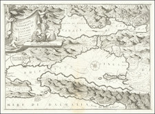
Detailed map of the northern part of the Kingdom of Hungary, along with Transylvania, Moldovia, Bessarabia, Romania, Macedonia, Albania, Bulgaria, Bosnia, Croatia, Serbia, Dalmatia, Slovenia, and part of Ukraine and western Turkey, published by Sanson.
The map is centered on the region between the Danube and the Carpathian Mountains and locate many major cities in the region, including Vienna, Brno, Poson/Presburg (Bratislava), Zagreb, Budapest, Saraio (Sarajevo), and Constantinople
This is the 1698 edition of the map. We note also editions dated 1679 and 1689.
Nicholas Sanson (1600-1667) is considered the father of French cartography in its golden age from the mid-seventeenth century to the mid-eighteenth. Over the course of his career he produced over 300 maps; they are known for their clean style and extensive research. Sanson was largely responsible for beginning the shift of cartographic production and excellence from Amsterdam to Paris in the later-seventeenth century.
Sanson was born in Abbeville in Picardy. He made his first map at age twenty, a wall map of ancient Gaul. Upon moving to Paris, he gained the attention of Cardinal Richelieu, who made an introduction of Sanson to King Louis XIII. This led to Sanson's tutoring of the king and the granting of the title ingenieur-geographe du roi.
His success can be chalked up to his geographic and research skills, but also to his partnership with Pierre Mariette. Early in his career, Sanson worked primarily with the publisher Melchior Tavernier. Mariette purchased Tavernier’s business in 1644. Sanson worked with Mariette until 1657, when the latter died. Mariette’s son, also Pierre, helped to publish the Cartes générales de toutes les parties du monde (1658), Sanson' atlas and the first French world atlas.
![(Second World War - Hungarian Air Defense Maps) Magyarorszag Legokorzetei [Hungarian Airspace]](https://storage.googleapis.com/raremaps/img/small/89125.jpg)
![Hungaria Ungarn [Hungary, Slovakia, Northern Croatia and Northern Serbia]](https://storage.googleapis.com/raremaps/img/small/76437mp2.jpg)
![(Second World War - Soviet Invasion of Romania) [Troop Movements in the Vicinity of Gura Humorului]](https://storage.googleapis.com/raremaps/img/small/89328.jpg)
![[Composite Lafreri-style Atlas of Battle Plans and Fortifications]](https://storage.googleapis.com/raremaps/img/small/92702.jpg)