|
||

|

|
|

|
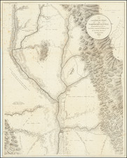
Rare map of Mexico, pubilshed 3 years after its independence from Spain, by Henry Fisher of London.
The map divides Mexico into several primary regions:
- Internal Provinces
- New California
- California
- Mexico
- Oaxaca
- Chiapa
- Yucatan
The large section above the Internal provinces which would become Texas is unnamed, a curious omission following the conclusion of the Adams-Onis Treaty in 1819 and foreshadowing the American movement into Texas beginning with Moses Austin. The area corresponds with the area inhabited by the Comanche.
The 1824 Constitution of Mexico joined Texas with Coahuila to form the state of Coahuila y Tejas. The Mexican Congress did allow Texas the option of forming its own state "as soon as it feels capable of doing so." In the same year, Mexico enacted the General Colonization Law, which enabled all heads of household, regardless of race or immigrant status, to claim land in Mexico. Mexico had neither manpower nor funds to protect settlers from near-constant Comanche raids and it hoped that getting more settlers into the area could control the raids. The government liberalized its immigration policies, allowing for settlers from the United States to immigrate to Texas.
The first empresarial grant had been made under Spanish control to Moses Austin. The grant was passed to his son Stephen F. Austin, whose settlers, known as the Old Three Hundred, settled along the Brazos River in 1822. The grant was later ratified by the Mexican government.
![[ Mexican Railroads ] Carta De Comunicaciones De Los Estados Unidos Mexicanos Formada de orden de la Secretaria de Estado y del Despacho de Comunicaciones y Obras Publicas, por el Coronel Bodo von Glumer . . . Primera Hoja. 1895 - 1896. (and) Segunda Hoja 1895 - 1896](https://storage.googleapis.com/raremaps/img/small/103235.jpg)