This item has been sold, but you can enter your email address to be notified if another example becomes available.


|
||

|

|
|

|
Stock# 56554
Description
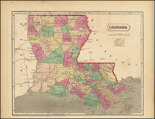
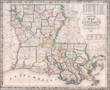
Gorgeous example of Tanner's map of Louisiana, with a large inset map of New Orleans.
The map is hand colored by county and shows towns, rivers, canals, roads, railroads etc. A key lists steamship routes and distances.
Tanner's maps are now quite scarce.
Condition Description
Minor foxing, mostly in the blank margins