


|
||

|

|
|

|
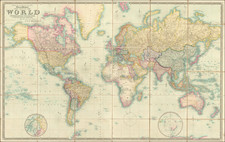
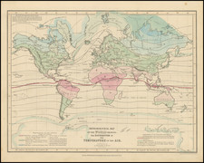
Fine old color example of this scarce large format map of the World, published in London by J. & C. Walker.
This revised edition of Walker's large-scale map of the World was issued in conjunction with the signing of the Treaty of Guadeloupe Hidalgo (1848), by which Texas, California and the Rocky Mountain States were officially joined to the United States. The plate was only partially revised, however, and the name of Mexico still extends across the greater part of the American West.
Appearing one year prior to the California Gold Rush, the map also pre-dates the Gadsden Purchase. Alaska is Russian America.
In Canada, many of the Forts and trading houses established by the Hudson's Bay Company are shown.
Of note are the early discoveries listed in the Antarctic:
- Enderby Land discoverd by Capt Biscoe in 1831
- Land seen by Capt Kemp in 1833
- Land discovered by Capt. Willkes, US Navy in January 1840
- Land discovered by Capt. D'Urville in 1840
- South Shetland Coastline, discovered by Biscoe in February 1832
- The large inset shows the routes of Balleny in 1839, Cook in 1773 and 1774, Belinghausen in 1820, Kemp in 1833, Biscoe in 1822 and 1831, and Ross in 1841 and 1842
In the Arctic Regions, recent discoveries are shown, including:
- Lands discovered by Simson and Dease on the north coast of Alaska
- Lands discovered by Franklin Richardson and Back
- Anjou's discoveries, 1821-23, in the Liakhov Islands
- Lands in Greenland examined by Claveing in and Scoresby ion 1822
The interior of Africa is largely unmapped, as is the interior of Australia, which includes the region named Australia Felix (western Victoria).
J. & C. Walker was the imprint used by the Walker family of engravers and printers. They produced numerous high-quality geographical maps and nautical charts for a variety of institutions in the nineteenth century. John Walker (1787-1873) held the position of Hydrographer to the East India Company, a position also held by his father and namesake. John worked in partnership with his brothers, Charles and Alexander. The brothers published over 200 maps for the Society for the Diffusion of Useful Knowledge. They produced maps for James Horsburgh and the Admiralty, as well as the influential Indian Atlas.
![[Terrestrial Globe Gore] and [Celestial Globe Gore]](https://storage.googleapis.com/raremaps/img/small/91969.jpg)