|
||

|

|
|

|
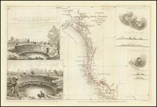
Rare Separately-Issued Chart of Western Australia from Freycinet's Surveys as Part of the Baudin Expedition
Intricately detailed chart of the coastline of Western Australia, which until this time had only been sporadically encountered by Dutch ships blown off course.
The survey was completed by Louis Claude Desaulses de Freycinet while part of the Baudin expedition. It was published in his celebrated and very rare hydrographic atlas, part of the official account of the expedition. This example is special in that it is a separately issued sheet from the French Hydrographic Office, sold for 1.5 francs.
The chart shows the Terre d'Endracht and the Terre d'Edels, both references to previous Dutch ships that visited the coastline. The title explains that the chart shows the results of a survey undertaken by Freycinet in the 29-foot Casaurina, but it actually shows the survey routes of the little Casaurina as well as those of boats of the larger ships associated with the Baudin expedition, the aptly-named Geographe and the Naturaliste. The routes of each vessel are differentiated with varying hash marks, dots, etc.
In the lower left corner is an inset showing four historical views of the Abrolhos Islands. In a text box to the right, Freycinet explains that the actual placement of the islands is an estimate, as their coordinates are still uncertain. He also explains his method of recording the soundings.
The chart is unadorned and contains no decorations; it was mean to simply and clearly communicate the extensive survey undertaken by the French despite the presence of another British voyage, that of the British Royal Naval officer Matthew Flinders, which was also surveying Australia at the time.
Hartog's pewter dish and Dutch exploration of Western Australia
The coastlines of Western Australia are based on early Dutch discoveries, including ships that were stranded, shipwrecked, and blown off course. The most noteworthy Dutch discovery recorded here is that of the Eendracht, which was blown off course en route to the East Indies in 1616. It was commanded by Dirk Hartog, commemorated with the Ile Dirck-Hartighs as written on this chart.
Hartog's landing was the first recorded European landing on the western coast of Australia and the crew commemorated their discovery by erecting a post with a pewter dish inscribed with their ship's information-the earliest physical record that historians have of any European landing in Australia. Hartog returned to tell of his feat to his employer, the Dutch East India Company (VOC), and the feature entered maps as early as 1623.
The dish marked the place of Hartog's landing until 1697, when it was found by another Dutch crew, led by Willem de Vlamingh. Vlamingh took the original and replaced it with a copy that also recorded his visit. The original dish was placed in the VOC's archives. Vlamingh's dish stayed in place and was found, fallen over, by the French explorer Jacques Felix Emmanuel Hamelin, whose name also graces this chart, in 1801. Hamelin commanded the Naturaliste on the Baudin expedition, the same expedition of which Freycinet was a part and on which he made this survey. It was Freycinet who named Cape de l'Inscription, at the northern end of the island, which is where the posts and dishes were erected.
Hamelin reattached the dish to its post, but it was taken down by none other than Louis de Freycinet when he commanded his own expedition to the coast in 1818. Freycinet had disagreed with Hamelin that the plate should be left in place; Hamelin thought it sacrilege to remove the relic while Freycinet thought it sacrilege to continue to expose such a historical item to the elements. Freycinet took it back to France with him, where it was lost. Only in 1940 did the dish reappear, in a store cupboard in the French Academy. It was presented as a gift to Australia in 1947. Today, it is on display at the Western Australia Museum. The original Hartog plate is at the Rijksmueum in Amsterdam.
The chart's title also mentions Terre d'Edels. Jacob d'Edel, in the Amsterdam, along with Frederik de Houtman in the Dordrecht came within sight of the western coast and called the stretch of land d'Edelsland. They then turned north and traced the lands first seen by Hartog and his men. Houtman connected these lands to Marco Polo's lands of Beach and Lucach (Locach), a common cartographic choice when referring to the southern continent.
Abrolhos Islands
Houtman also was responsible for naming the Abrolhos Islands, an archipelago. Houtman sighted the islands, or at least it was Houtman who reported the islands to the VOC. The name Houtman's Abrolhos, as used on this chart, was first used in Hessel Gerritszoon's 1627 chart Caert van't Landt van d'Eendracht. However, the most important map for the islands was Johannes Van Keulen's chart which circulated widely in the eighteenth century and was reprinted by Alexander Dalrymple.
The inset in the lower left showcases two details from Van Keulen's rendering of the islands, as well as one from Jacobsz Lootsman. The fourth is from a Captain Daniel, dated 1681. This refers to John Daniel, an English navigator who charted part of the western Australian coast in the New London. Daniel labelled the islands, "dangerous rocks."
The rocks were extremely dangerous and have caused several shipwrecks. The most infamous of these was the wreck of the unfortunate Batavia in 1627. The mutiny and massacre that became Batavia's fate fascinated all of Europe, but also flagged the islands as treacherous for ships, which is why they deserve such attention on this chart.
Louis Freycinet and the Baudin Expedition
This chart featured in the rarest of the volumes to come out of the Baudin expedition. When Nicolas Baudin left Le Havre in the Geographe and the Naturaliste in October 1800, he was embarking on a voyage meant to survey the shores of Australia. At this time, the British had established their presence in eastern Australia, but the western and southern portions of the continent remained unexplored and not necessarily claimed by the British. In other words, although ostensibly a scientific expedition, the French were also open to possible overseas expansion if the opportunity arose.
In the Naturaliste, commanded by aforementioned Captain Hamelin, was Louis Freycinet, then only 21 years old. He had joined the French Navy in 1793 and was accompanied on this voyage by his brother, Louis-Henri, who would go on to become an admiral. Henri Freycinet also has his own geographical feature on this chart, the Havre Henri Freycinet.
Initially the ships, sometimes separated, made their way north up the western coast of Australia from Cape Leeuwin to Timor. They then went south again, but were separated a second time. Baudin and the Geographe made for Van Diemen's Land and then returned toward the west. En route, they encountered British naval officer Matthew Flinders in the Investigator. Flinders, on his third Australian surveying mission, was heading to Sydney, from where he would begin a clockwise circumnavigation of the Australian continent, the first such voyage to ever do so. Flinders named the place where he and Baudin met Encounter Bay.
Baudin and Hamelin were reunited in Sydney, where both ships had come to recuperate in late 1801. While there, Baudin purchased a 29-foot vessel. He named it Casuarina and placed Freycinet, who had proved himself an adroit hydrographer under Hamelin, in command. With his new charge, Freycinet was to perform inshore surveys.
During the course of 1802, the Naturaliste and the Casuarina surveyed the southern coast of Australia (the Naturaliste had been sent back to France). They then sailed round the west coast to Timor, then back to Mauritius, where Baudin died. It was also where the Casuarina's career ended, as the ship was abandoned in favor of consolidating the crews on the Geographe. The ship returned home on March 25, 1804.
The publication of the voyage accounts and atlas
This map chronicles the work of these ships and was part of the rare hydrographic atlas published in 1812. Although they were largely repeating work already done by Matthew Flinders, some of the French toponyms survive today, such as Cape Inscription. This is due in large part to the fact that this chart was finished before Flinders could produce his own account of his Australian circumnavigation. He had published several charts of his 1798 expedition, which were used by Freycinet, but Freycinet's work shows a much larger and more complete area, lending it importance and primacy.
Why did Flinders take so long to publish his own findings, yielding the novelty of publishing the charting of the Australian coastline to the French? Flinders left New Holland in 1803 and arrived in Mauritius to water and repair his leaky vessel on December 15, 1803. Unfortunately, word had reached the French-controlled island only three weeks prior to his arrival that the British had ruptured the fragile Peace of Amiens; the French and British were at war once again. The French governor, General Decaen, detained Flinders after the British officer was not entirely polite. Flinders was kept against his will on the island for six and a half years, returning to England only in October of 1810. Additionally, the French seized his papers, including the ships logs, though they were eventually returned in part.
Freycinet, meanwhile, had returned to France in 1804. Since Baudin had died in Mauritius, the naturalist Francois Peron and Freycinet were directed to prepare for publication the official account of the voyage, with an accompanying atlas. Baudin was not generally well liked by his fellow sailors, a fact borne out by the limited reference made to him or his discoveries in the narrative and maps of the voyage. The French maps also do not recognize the prior claims of first discovery by men like Flinders, in an attempt to give France more prominence. However, Freycinet did likely have access to copies of Flinders' documents seized when he was imprisoned, improving the detail of his charts.
The official account appeared over ten years and in four volumes. The first narrative of the voyage, primarily by Peron, was published in 1807. The second narrative volume was published in 1816 and was written primarily by Freycinet. Peron had died in 1810. The first part of the Atlas, which contained 40 engraved plates, two of them folding, appeared in 1807. The second atlas, was published in 1811 with 14 engraved charts, two of them double-page. These double-page maps include a map of the Australian continent, the first map to show the continent in its entirety and made partially from Flinders' papers.
The map shown here was part of the rarest of the volumes prepared by Freycinet, the hydrographic atlas dated 1812, although it was not distributed until 1814. It contained 32 engraved charts, 25 of them double-page. An accompanying text volume was published in 1815, also by Freycinet.
By contrast, Flinders' narrative and atlas of his own account appeared only in 1814, almost a decade after the first maps of the Baudin expedition were published and three years after the completion of this chart.
Freycinet's later career
The publications stemming from the Baudin expedition would have been enough to secure the fame of Louis Freycinet. However, he is perhaps best known today for his second voyage to the Pacific, one he commanded in the Uranie. From 1817 to 1820, Freycinet cruised the Pacific performing experiments and, of course, making detailed charts. He was accompanied by his wife Rose.
Although the Uranie was wrecked in the Falklands on the return journey, the natural historical specimens and geographical notes were saved, as was de Vlamingh's pewter dish. They were published in 13 volumes with 4 additional volumes of plates and maps between 1824 and 1844.
The voyage secured Freycinet a place in the Academie des Sciences. He also went on to help found the Paris Geographical Society, the first such group of its kind. Louis Freycinet died in 1841.
Rarity
The hydrographic atlas is the rarest of the Baudin publications, many times rarer than the narrative, and it is seldom on the market. A separately issued print like this is very rare, especially in such good condition.
discovery. New Haven: Yale University Press, 2015.
Louis Claude Desaulses de Freycinet (1779-1841) was a French hydrographer and explorer. He joined the French Navy in 1793. In October 1800, at the age of 21, Freycinet set off in the Naturaliste, part of an exploratory expedition to chart Australia. He was accompanied on this voyage by his brother, Louis-Henri, who would go on to become an admiral.
In Sydney, the leader of the expedition, Nicholas Baudin, purchased a 29-foot vessel. He named it Casuarina and placed Freycinet, who had proven himself an adroit hydrographer, in command. With his new charge, Freycinet was to perform inshore surveys. During the course of 1802, the Casuarina charted large portion of the southern coast of Australia.
Freycinet returned to France in 1804. Since Baudin had died in Mauritius, the naturalist Francois Peron and Freycinet were directed to prepare for publication the official account of the voyage, with an accompanying atlas. The official account appeared over ten years and in four volumes. The first narrative of the voyage, primarily by Peron, was published in 1807. The second narrative volume was published in 1816 and was written primarily by Freycinet. Peron had died in 1810. The first part of the Atlas, which contained 40 engraved plates, two of them folding, appeared in 1807. The second atlas, was published in 1811 with 14 engraved charts, two of them double-page. These double-page maps include a map of the Australian continent, the first map to show the continent in its entirety and made partially from Matthew Flinders’ papers.
His publications stemming from the Baudin expedition would have been enough to secure the fame of Louis Freycinet. However, he is perhaps best known today for his second voyage to the Pacific, one he commanded in the Uranie. From 1817 to 1820, Freycinet cruised the Pacific performing experiments and, of course, making detailed charts. He was accompanied by his wife Rose.
Although the Uranie was wrecked in the Falklands on the return journey, the natural historical specimens and geographical notes were saved. They were published in 13 volumes with 4 additional volumes of plates and maps between 1824 and 1844.
The voyage secured Freycinet a place in the Academie des Sciences. He also went on to help found the Paris Geographical Society, the first such group of its kind. Louis Freycinet died in 1841.