This item has been sold, but you can enter your email address to be notified if another example becomes available.


|
||

|

|
|

|
Stock# 48641
Description
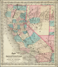
Fine large format Railroad map of California, issued by the State Railroad Commission.
The map is remarkably detailed, identifying 15 operating lines (color coded) and providing remarkable detail throughout.
The inset of Los Angeles and Vicinity has been updated with an onlaid piece of paper over San Pedro Bay.
These maps were apparently issued periodically. We note editions of 1915, 1922 (OCLC locates 2 copies) and 1926 (3 copies).
Similar but different from Scarborough's California Map. Insets of San Francisco, Los Angeles, Sacramento and San Diego.
Shows Steam and electric railway lines in operation, national parks and forests and distances from San Francisco.
Condition Description
Mounted on linen. Small loss in the inset of Los Angeles and Vicinity.