


|
||

|

|
|

|
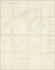
Rare chart of Kodiak Island, with insets of its various bays, etc., published by the Russian American Company.
This map was published as part of the Russian American Company's report for 1848. It shows Kodiak Island flanked by ten insets of bays and harbors.
While the map reveals a thorough knowledge of the topography of the northern and central regions of the island, the southern parts remain hypothetical, revealing the remoteness of this Russian outpost. However, the details that the map does show, are extraordinary and predate British and American surveys by decades.
The Russian American Company, founded in 1799 as Russia's first joint-stock company, was establish as a colonial presence in America via settlement, trade with indigenous people and mining of the rich resources of what is today the Pacific Northwest. The Company also worked in concert with intellectual societies, most notably the Russian Academy of Sciences, to plan and support expeditions intended to gather geographic and natural historical information. This map appeared under the governorship of Baron Von Wrangel, explorer and hydrographer.
Kodiak holds an important place within the geography of Russian Alaska. It served as a stopping-place, a base for expeditions, and as a (contested) source of labor in the form of the Kodiak Islanders. The encampment there, established in 1784, was the second permanent Russian settlement in Alaska. Thus, this map shows a time when Russia seemed likely to become an enduring presence in North America, although they had ceded their claim to California in 1841. It captures a moment when the Pacific Northwest was hotly contested by Russians, Americans, the British, and the indigenous peoples who originally inhabited the land.
The Russian American Company
The "Russian-American Company Under the Supreme Patronage of His Imperial Majesty" was a state-sponsored chartered company formed largely on the basis of the United American Company. The company was chartered in 1799, and was mainly expected to establish new settlements in Russian America and carry out an expanded colonization program.
Count Rumyantsev funded Russia's first naval circumnavigation under the joint command of Adam Johann von Krusenstern and Nikolai Rezanov in 1803-1806, and later funded and directed the voyage of the Ryurik's circumnavigation of 1814-1816, which provided substantial scientific information on Alaska's and California's flora and fauna, and important ethnographic information on Alaskan and Californian (among others) natives. Bodega Bay, California, was initially named "Rumyantsev Bay" and was named in his honor during the Russian-California period (1812-1842) of Fort Ross.
![America [Manuscript Map Showing the Sea of the West!]](https://storage.googleapis.com/raremaps/img/small/41297dm.jpg)