|
||

|

|
|

|
Stock# 78544
Description
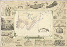
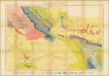
The Geological Survey Maps the North Slope.
An apparent working draft of a geological map of the Colville River Basin in northern Alaska, from the slopes of the Brook Range to the confluence of the Colville with the Chandler and Anaktuvuk Rivers.
The map shows the results of geological investigations along exposure along each of the rivers, with contacts, folds, and other structures. The map includes a table of strata to the right, but the map is not colored in. Further, manuscript annotations are made to the map, suggesting that this may be a working copy.
Condition Description
Some manuscript additions.