


|
||

|

|
|

|
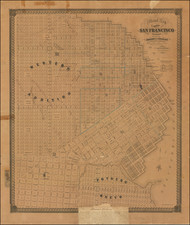
Fine example of Augustus Chevalier's fine large format map of San Francisco, re-issued and annotated for use by tourists during the Panama-Pacific Exposition of 1915.
Augustus Chevalier issued a number of fine maps of San Francisco, including a monumental wall map. By the early 20th Century, his maps of San Francisco were perhaps the best known and respected of the City. The present map was first published in 1915, replacing a vertically formatted map of the same title, first issued in 1904.
The 1914 map was annotated to include details in red showing the Street Car Lines, Proposed Tunnels and the Market Street Extension. The map is a reduced size copy of Chevalier's wall map of 1911, which measure nearly over 5 feet tall and incorporated the same elegant title, with the Seal of the City and County of San Francisco, although the title is on the right side of the map. This edition, dated 1915 and referencing "The Exposition City," was designed specifically for the Panama-Pacific Exposition and, unlike the 1911 wall map, incorporates a detailed plan of the Exposition Grounds just east of Fort Point and the Aviation & Athletic Field and Race Track and just west of Fort Mason.
A second edition of the Exposition City map was issued in 1915, with the title on the right side and a longer legend below the title. The present edition, with the title on the left side, is apparently quite scarce, as we were not able to locate another example.
![[ San Francisco and California Coast to Central Baja ] Cote Nord-Ouest De L'Amerique Reconnue par le Cape. Vancouver Ie. Partie . . .](https://storage.googleapis.com/raremaps/img/small/82224.jpg)