This item has been sold, but you can enter your email address to be notified if another example becomes available.


|
||

|

|
|

|
Stock# 36151
Description
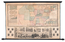
Detailed map of the southeastern United States showing fortifications, troop movements, etc.
The dark lines indicating the movement of Sherman's forces in Georgia and Tennessee. a list of authorities is given. The map also shows cavalry and infantry routes, railroads, rivers, and other detailed information. Routes taken by McPherson, Thomas, Schofield, Hooker and others are delineated.
A remarkably detailed military map, generally regarded as the best contemporaneous cartographic record of the Georgia campaign.
Condition Description
Losses and minor discloration along several folds
Reference
Stevenson 72; McElfresh, E. Maps & Mapmakers of the Civil War, pp. 244-45
![[ Atlantic Ocean / Triangular Trade / Negroland ]](https://storage.googleapis.com/raremaps/img/small/65187.jpg)
![[HAPAG Map of the United States and Canada]](https://storage.googleapis.com/raremaps/img/small/78779.jpg)