


|
||

|

|
|

|
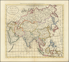
Fine example of Tobias Conrad Lotter's large format map of Asia with attractive wash color.
This attractive map is largely based on the cartography of the French Royal geographer, Guillaume de L'Isle. It embraces the whole of Asia, including the East Indies and the tip of New Guinea. Japan is connected to the mainland by a country identified as Terra Yeco (roughly the location of modern Hokkaido). Further to the Northwest is the fictional 'Terra de la Compagnie', while Korea is shown as a peninsula. Eastern Siberia is shown to be complete enigma, as knowledge extends barely beyond the Urals and the Arctic beyond Novaya Zemlya, first charted by discovered by Willem Barents in 1594. Notably, with the depiction of Southeast Asia, Indochina, Indonesia and the Philippines gradually assume their true outlines.
Tobias Conrad Lotter (1717-77) of Augsburg married into Matthaeus Seutter's well-established publishing business. He became one of the most prolific cartographic publishers on the Continent, and produced a vast array of fine maps ranging in scope from double hemispheres to celestial charts. Lotter took over Seutter's business in 1756 and continued to publish Seutter's reworked plates until his death in 1777. After his death, the firm was taken over by his son, Mathias Albrecht Lotter who republished and updated many of his father's maps.
Tobias Conrad Lotter (1717-1777) is one of the best-known German mapmakers of the eighteenth century. He engraved many of the maps published by Matthaus Seutter, to whose daughter Lotter was married. He took over Seutter’s business in 1756. Lotter’s son, M. A. Lotter, succeeded his father in the business.

![(1st State) [ First Map of Asian Continent ] India Extrema XIX Nova Tabula](https://storage.googleapis.com/raremaps/img/small/94610.jpg)
![I. a [Asia]](https://storage.googleapis.com/raremaps/img/small/93297.jpg)
![[ Dalai Lama ] Grand Lama](https://storage.googleapis.com/raremaps/img/small/97873.jpg)