This item has been sold, but you can enter your email address to be notified if another example becomes available.


|
||

|

|
|

|
Stock# 28912
Description
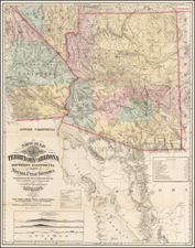
Detailed early map of San Diego with a large inset map of La Jolla.
The map shows Fort Rosecrans, the US Naval Air Station, the Naval Fuel Depot, US Marine Corps Base and US Naval Training Station. Mission Beach is subdivided (1915), and the bridge across the Mission Bay Channel, connecting Ocean Beach and Pacific Beach, has been constructed.
Condition Description
Minor toning and loss along one fold
![[ Hungarian Traveler In the California and the West with a Comanche and Wichita to Hungarian vocabulary ] Levelei Éjszakamerikából -- Tizenkét eredeti rajzok után készült kő- és egynéhány fametszettel. Közli Prépost István (Letters from North America)](https://storage.googleapis.com/raremaps/img/small/98502.jpg)
![[ California To Alaska -- Northwest Passage ] Quivirae Regnu cum alijs versus Borea](https://storage.googleapis.com/raremaps/img/small/60083.jpg)

![(Bird's-Eye View of California) San Francisco Invites You [cover title]](https://storage.googleapis.com/raremaps/img/small/92552.jpg)