|
||

|

|
|

|
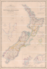
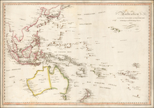
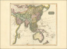
Fascinating map of New Holland (Australia), New Zealand and neighboring islands, along with "The Settlement of Port Jackson."
The south coast of Australia is largely undiscovered and shown as conjectural. The only settlements area along the east coast, with New South Wales the only province named. The west coast reflects the naems of several early Dutch explorers (de Wit, Edel's Land, Lewens Land and VAn Diemen's Land, both in the North and South) along with the date of discovery by de Wit (1628). New Zealand is still shown as only 2 islands (Taviapoenammoo and Eaheinomauwe). A number of the islands north and east of Australia are shown with incomplete coastlines.
John Cary (1755-1835) was a British cartographer and publisher best known for his clean engraving and distinct style which influenced the entire map industry. Born in Wiltshire, John was apprenticed to an engraver in London. He started his own business by 1782 and moved to several premises before settling at 86 St James’s Street in 1820.
Cary had several significant collaborations during his career. John Wallis and Cary diversified Cary’s business to include broader publishing projects. Brother William and John made globes together, while brother Francis participated in the company’s engraving work. Finally, geologist William Smith and Cary developed and sold geological maps, some of the first of their kind. The pair also produced a notable series of county maps starting in 1819. Cary’s atlases, of English counties and the world, were the standard texts of the early nineteenth century. He was appointed surveyor of roads to the General Post Office in 1794, which led to the New Itinerary, first published in 1798.
John trained his son, George, in engraving and George and his other son, John Jr., took over the business in 1821. It was then known as G. and J. Cary and continued in trade until 1850. The firm’s materials were then acquired by George Frederick Cruchley and then Gall and Inglis. By the time John died in 1835, Cary was the authoritative name in private map publishing and his business was a leader in the field throughout the first half of the nineteenth century.