|
||

|

|
|

|
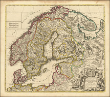
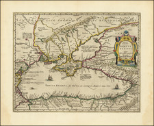
Rare 4-sheet map of the Theater of War between the Russians and the Ottoman Empire, showing the region bounded by Greece, Cyprus, Asia Minor, Turkey, Ukraine, Lithuania, Black Sea, and contiguous regions.
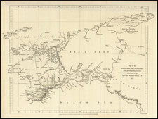
This extremely rare 4 sheet map of the Theater of War incorporates a single sheet map issued in 1769 by the Facius Brothers in Bonn, adding a small extension sheet to to the west and 2 sheets below, in order to show the entire theater. The full title of the map is:
Carte exacte d'une Partie de L'Empire de Russie et de la Pologne meridionale renfermant l'Ukraine, la Podolie, la Volhynie, la Rusfie, la petite Pologne, la Mazovie, et une Partie de la Lithuanie avec la petite Tartarie la Moldavie la Valaquie et la Transylvanie Suivant le meilleurs auteurs par J et F 1769. Francfort sur le M., Jäger. - Seconde Feuille du Theatre de la Guerre entre les Russes et les Turcs contenant la Bulgarie la Macedonie la Thracie la Natolie ou petite Asie les Isles de Morèe de Candie de Cypre et les autres Isles de l'Archipel avec le reste de la Mer noire et celle de Marmore dressée suivant la Carte de Hase et corrigée d'après les observations et les Cartes de Pocock faites de ses voyages dans ces païs la. Francfort sur le M. 1770.
The only reference to the map which we have located is in the Katalog der von Sr. Maj. dem Konig Freidrich August von Sachsen nachgelassenen Kartensammlung, published in Dreseden in 1860 and the Landesarchiv Baden-Wurttemberg. The lower 2 sheets are referenced in Zacharakis (1699 / 2611), without reference to the rest of the map. The upper right sheet of this map, which was issued the prior year by Facis in Bonn, has been revised and includes a number of revisions to this sheet, which are not on the first, including a change to the title and geographical information. The most obvious of the changes is an annotation to the west of the Bug River, below Nouvelle Servie and a second annotation slightly below and the the right of the first, an annotation near the town of Kanenoiston on the lower Dniepr River and one above the Tartar limits, none of which appear on the first edition. To view the first edition, click here: /gallery/detail/22234
This expanded 4-sheet edition of the map provides a highly detailed treatment of Cyprus, Asia Minor, Turkey and Greece, combining with the top sheet to provide an excellent depiction of the Theater of War beween the Russians and Ottoman Empire.
The Facius brothers were born in Regensburg and trained as engravers in Brussells. By 1776, there work had become well respected and they moved to London, at the request of John Boydell, with whom they worked for a number of years as engravers. As the map was produced when they were still quite young and because they did so few maps, the map is also interesting as a rare example of their work in cartographic material.