|
||

|

|
|

|
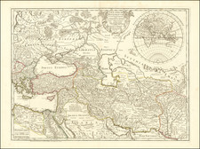
Very attractive original antique map of the Black Sea, complete with extensive detail and attractive coloring. This map originally appeared in Jan Janssonius's Description Exacte de l'Univers: ou l'Ancienne Geographie Sacree et Profane.
Numerous notes can be found throughout the map, describing the geography of the region. Two ships can be seen sailing on the ocean. Numerous cities are found throughout the map, and all the rivers discharging into the Black Sea are shown.
This map is copied after Ortelius's map which originally appeared in 1590. As in the Ortelius example, in the cartouche the name of the Black Sea, "Pontus Euxinus", is transcribed into Cyrillic lettering.
Jan Janssonius (also known as Johann or Jan Jansson or Janszoon) (1588-1664) was a renowned geographer and publisher of the seventeenth century, when the Dutch dominated map publishing in Europe. Born in Arnhem, Jan was first exposed to the trade via his father, who was also a bookseller and publisher. In 1612, Jan married the daughter of Jodocus Hondius, who was also a prominent mapmaker and seller. Jonssonius’ first maps date from 1616.
In the 1630s, Janssonius worked with his brother-in-law, Henricus Hondius. Their most successful venture was to reissue the Mercator-Hondius atlas. Jodocus Hondius had acquired the plates to the Mercator atlas, first published in 1595, and added 36 additional maps. After Hondius died in 1612, Henricus took over publication; Janssonius joined the venture in 1633. Eventually, the atlas was renamed the Atlas Novus and then the Atlas Major, by which time it had expanded to eleven volumes. Janssonius is also well known for his volume of English county maps, published in 1646.
Janssonius died in Amsterdam in 1664. His son-in-law, Johannes van Waesbergen, took over his business. Eventually, many of Janssonius’ plates were sold to Gerard Valck and Pieter Schenk, who added their names and continued to reissue the maps.
![[Spitzbergen & Wiches Lande]](https://storage.googleapis.com/raremaps/img/small/61990.jpg)