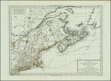
Rare separately issued example of Bradock Mead's remarkable large format map of New England & Long Island.
First published by ThomasJefferys in 1755, at the outset of the French & Indian War, Bradock Mead's map became the single most influential map of New England for the next four decadesyears, influencing most of the significant policy and boundary decisions of the later part of the English Colonial Period.
The map was prepared by Bradock Mead (alias John Green), one of the more colorful characters of the map period, whose failed plan to kidnap and either marry or extort a large ransom for the return of an heiress resulted in his spending the majority of his life underground on the fringes of London's map and print publishing business.
The map is an amalgam of contemporary sources, which are identified in table in the upper right portion of the map. However, Douglass' Plan of the British Dominions of New England in North America is a curious (and obvious) omission. Jeffrey's map represents the first widely disseminated large format depiction of the region and a substantial improvement from the Douglass map, in part because of the additional territory covered and almost certainly the additional information which was likely available to Jeffreys and Mead in the several years following the issue of the Douglass map.
The map includes a pictorial cartouche, showing the Pilgrim's landing at Plymouth Rock in 1620 (the dat being shown on the rock on the right side of the cartouche.
While atlas copies of the map appear occasionally on the market, separately issued examples are very rare. The present example includes markings on the verso of the linen suggesting that its first owner was German and this may have been either a field map or otherwise utilized by its owner during the American Revolution.
Thomas Jefferys (c. 1719–1771) was a prolific map publisher, engraver, and cartographer based in London, known for his significant contributions to the cartography of North America and the West Indies during the 18th century. Jefferys was born to a cutler but was apprenticed to Emanuel Bowen, a prominent mapmaker and engraver. He gained his freedom from the Merchant Taylors’ Company in 1744, although he had already produced maps under his name as early as 1732. Throughout his career, Jefferys collaborated with several partners, including Thomas Kitchin, with whom he published The Small English Atlas in 1748-9, and Robert Sayer, with whom he co-created A General Topography of North America in 1768. Sayer also published posthumous collections featuring Jefferys' work, such as The American Atlas, The North-American Pilot, and The West-India Atlas.
Jefferys served as the Geographer to Frederick, Prince of Wales, and from 1760, to King George III. His role primarily involved supplying maps to the royal family, particularly during the height of the Seven Years' War, which spurred demand for detailed and accurate maps of North America. Jefferys not only sold maps commercially but also maintained connections with government bodies for whom he produced specialized materials, further solidifying his status in the map trade.
Despite his success and royal appointments, Jefferys faced financial difficulties, leading to bankruptcy in 1766. His business and map plates were eventually acquired by Robert Sayer and other associates. Upon Jefferys' death in 1771, his workshop passed to his son, Thomas Jr., and his partner, William Faden. Although Jefferys was known primarily as an engraver, producing illustrations and drawings in addition to maps, his contributions to the field of cartography remain his most enduring legacy.
Jefferys had no formal geographical training, and his early work was largely confined to engraving maps compiled by others or revising existing plates. However, his collaboration with John Green, a skilled cartographer also known as Bradock Mead, significantly enhanced his reputation. Mead, an Irishman with a complex personal history, was known for his expertise in map-making and was instrumental in creating some of the detailed maps that Jefferys published, including the influential New Map of Nova Scotia and Cape Britain in 1755. Mead's work underpinned much of Jefferys' acclaim as a leading map publisher of his time.
From 1750 onwards, Jefferys began to focus on maps of America, a region of increasing interest to British audiences. His notable works included a series of maps detailing North America, which bolstered his reputation as the preeminent map and chart supplier of his era. He continued to produce maps even after his financial collapse, but his later years were marked by financial instability. Despite this, his maps were in high demand and were republished by Sayer and Bennett, his former associates, who continued to use Jefferys' name to ensure commercial success.
Jefferys' legacy is characterized by his comprehensive atlases and detailed maps that captured the geographic and political landscapes of the 18th century. His work remains significant not only for its historical and cartographic value but also for its role in the broader narrative of colonial expansion and exploration. His contributions, preserved through subsequent editions and reprints, solidified his place as one of the leading figures in the history of cartography.
John Green is an alias for Bradock Mead (ca. 1688-1757). Raised in Dublin, his brother Thomas, served as Lord Mayor of the city in 1758-9. While in Dublin, he published The construction of maps and globes (London: 1717). He also became involved with a plot to kidnap an heiress. He escaped, but others in his group were not so lucky. He came to London and took on the name Rogers and worked as an amanuensis.
He was active in London from at least the early 1720s to 1755. Later, as Green, he translated du Halde’s Description géographique de la Chine into English for the publisher Edward Cave. He also worked on Astley’s voyage collection. However, he fell out with both men. From the 1730s onward, he worked periodically with Thomas Jeffreys, Geographer to Frederick Price of Wales and later to King George III. In 1757, he committed suicide by jumping from a third-story window.