


|
||

|

|
|

|
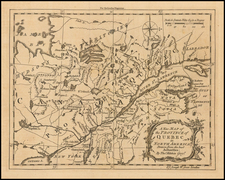
Extremely rare separately printed map of the Theater of War in North America, based upon an earlier map by Rigobert Bonne.
The map is an interesting early copy of Bonne's two sheet map of North America, which hasbeen updated to reflect the Theatre of War in North America during the American Revolution. The details the region embroiled in the conflict and extends from eastern Canada and Greenland to Tobago in the West Indies. In Canada, it includes an interesting depiction of a passage from Hudson Bay westward though a network of rivers and lakes alluding to a possible Northwest Passage to the Pacific. French Louisiana is sandwiched between Mexique and the British Colonies with their western boundary on the Mississippi River. Good detail of Indian villages and the numerous forts that played a role in the War of Independence. The Bonne map began life in 1771 with the title "Partie de l'Amerique Septentrionale, qui comprend le Canada, la Louisiane, le Labrador, le Groenland, la Nouvelle Angleterre, la Floride &c." It went through several editions to 1783, with title changes to reflect the changing political climate. This is the uncommon German edition of 1777.
The map has a crude engraving style, which is unlike similar maps ofthe period and likely reflects a hurried preparation for the market. The backwards "N"in Louisiane and uneve lettering and different lettering styles are indicative a rushed production, het hte attention to geographical details is quite obvious, with many forts, annotations and other points of interest shown on the map.
The only specific reference we could find to the map was the catalog entry in OCLC, locating the separate example of the map held by the Bayerische Staatbibliothek . The only early catalog annotation describing Muller's work is in the Bulletin of the New York Public Library (July 1909), which states:
Several purchases of Americana of more than usual interest have been made during the month. These include. . . the " Geographische Belustigungen zur Erläuterung der neuesten Weltgeschichte. Mit Landkarten, Planen und Kupfern nach den neuesten und besten Originalen. (Zum Besten einer Freyschule in Sachsen)," published at Leipzig by the Johann Carl Müllerischen Buch-und Kunsthandlung in 1776, 2 parts in i, 4°, in the original wrappers, uncut.
This latter included three interesting maps: (i) "Carte von dem Hafen und der Stadt Boston mit den umliegenden Gegenden und den Lägern sowohl der Americaner als auch der Engländer von dem Cheval de Beaurin nach dem Pariser Original von 1776;" (2) "Ein Theil des mitternächtlichen America welcher die Besitzungen der Englander in denselben begreift. Nach dem Original des Herrn Bonne, Paris, 1773, Leipzig bey J. C. Müller Buch und Kunsthaendler, 1777;" (3) " Der Teufels Belt gemeiniglich genannt der Lange Insels Sund."
However, unlike the example refeenced above, the present example was printed on thick paper and bound unfolded into what would appear to be a large folio composite atlas, almost certainly published during the American Revolution.
The work is of the utmost rarity. Sabin only notes the existence of the First Part (Sabin 2690), which includes a Boston area Plan of the Battle of Bunker Hill. The only American institutions holding copies of the Second Part are the New York Public Library and the example referenced in the 1830 Catalog for the holdings of Harvard Library (both of which were folded into quarto sized bindings. The only auction record for the work in modern times is for the first volume only (Bloomsbury 2008), in which the work (Part 1 only) was described as follows:
The German pamphlet [includes] reviews of the history of the English in North America, followed by sections on New England, Massachusetts, Connecticut, Rhode Island, New Hampshire, Maine, New York, New Jersey, Pennsylvania and Maryland. The map bound in the rear, titled Carte von dem Hafen und der Stadt Boston, is by Georg Friedrich Frentzel after one by Jean Chevalier de Beaurain published in Paris the same year. It includes three lettered references in the lower margin identifying the site of the 17 June 1775 Battle of Bunker Hill and delinates the positions of the American Army at Cambridge, Charlestown Neck and above Roxbury. The decorative cartouche includes a vignette depicting a British officer attempting to wrest a Liberty Pole from an American patriot.
A second part to this work treating the southern colonies containing a map of Long Island was also issued (but separately?). OCLC records only a single copy of this work with both parts (New York Public Library).
The example referenced above was apparently sold to Donald Heald following the Bloomsbury sale in 2008. The Heald catalog entry for the item (priced at $40,000) reads in relevant part as follows:
Müller apparently issued two parts to this work, both of which are exceptionally rare. There are no auction records; Sabin notes the present first part, but was evidently unaware of the existence of the second part, sub-titled "Allgemeine Beschreibung der engländischen Colonien in Nord-Amerika, nebst einer Karte von denselben und einer Karte von Long-Island." OCLC records only a single copy of this work (with both parts) in the New York Public Library (both Heald and Bloomsbury apparenty were not able to locate the John Carter Brown Copy).
In addition to the New York Public Library Copy, OCLC also locates the John Carter Brown copy, both in 2 volumes. OCLC locates the following examples of the Volume 1: Danish National LIbrary, Bayerische Staatbibliothek (which also catalogues individually the map of Long Island); and Sachische Landesbibliothek. OCLC locates the following examples of Volume 2 alone: Univ. Forsdchungbibliothek Erfurt Gotha and Sachische Landesbibliothek.
A fine example of this virtually unobtainable rarity, offered here in a unique format.
![[ British Colonies in North America & Caribbean ] L'Amerique Angloise, ou Description des Isles et Terres du Roi d'Angleterre dans l'Amerique, Avec de nouvelles Carte de chaque Isle & Terres](https://storage.googleapis.com/raremaps/img/small/102812.jpg)
![[Vermont schoolgirl manuscript map of the United States by Lucy Hosford of Ely, VT]](https://storage.googleapis.com/raremaps/img/small/85583.jpg)