|
||

|

|
|

|
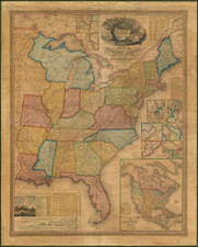
Remarkable large map of the United States, Mexico and British America, published as a collaboration between the American geologist Henry Rogers and the Scotish publishing firm of A.K. Johnston of Edinburgh.
The map provides a remakable snapshot of the United States and most notably the territorial boundaries of the Western US at one of the most fascinating points in the geopolitical evolution of its territorial boundaries. The map aslo showss cities, rivers, mountainous terrain, and railroad lines. The inset maps show prominent cities, including New York, Philadelphia, Boston, New Orleans, San Francisco, Montreal, Quebec, Louisville and Cincinnati. While the first edition of the map is quite rare (only 4 examples located on OCLC), the map apparently inspired a series of publications which lasted nearly 20 years. The partners followed the map in 1857 with the publication of their Atlas of the United States of North America, Canada, New Brunswick, Nova Scotia, Newfoundland, Mexico, Central America, Cuba, and Jamaica. On a Uniform Scale. From the Most Recent State Documents, Marine Surveys, and Unpublished Materials. With Plans of the Principal Cities and Sea-Ports, and an Introductory Essay on the Physical Geography, Products, and Resources of North America. London: Edward Stanford, 6, Charing Cross, S.W. In subsequent years, the Stanford firm would revise the map on an almost annual basis until the late 1870s. In addition, in 1873, map would again appear in Atlas format, in updated format, known as the People''s Pictorial Atlas and later the Jone's Historical Atlas. While the maps and even the printing process are different, the distnctive nature of the maps and attention to detail is unsurpassed for the period.
As noted by Rumsey, the atlas was an
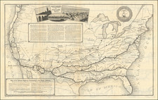
unusual collaboration between a Scot (Johnston), an American (Rogers), and an Englishman (Stanford). The maps are all on a scale of 54.5 miles to one inch, and are very well executed. They are derived from the large Map of The United States, British & Central America, by Rogers and Johnston, 1857 The western U.S. maps show the routes of the proposed Pacific Railroad. Rogers probably wrote the descriptive text. Johnston engraved and drew the maps-these maps are perhaps the best examples of Scottish highly detailed mapmaking applied to the western territories and states, in the pre-Civil War period.
The individual maps from the atlas have also drawn tremendous praise. In looking at several of the western maps, Wheat notes
Despite its American copyright the map bears the signs of having been produced in Europe. [The California map] extends east to Sevier Lake, and is a map carefully made (though none too accurate) and easily read. The mining region of California is not cluttered with too many names, and while the Nevada portion shows no route, the map is clear and distinct. Another of the maps...is the map of Utah, including Nevada and a large part of Arizona and New Mexico (south to Albuquerque). Utah (and Nevada) is divided into its counties, and the proposed railroad routes are colored purple. Gunnison's route goes out to the point on the Sevier River where he met his death. Beckwith's route is shown both east and west of Great Salt Lake, and the route along the Snake is shown at the top of the map. This map is, like the one previous, notable for its clarity, though it is equally notable for the amount of information that it contains. W. and A. K. Johnston, of Edinburgh, were engravers who well understood their art, and their maps are outstanding."
The Transmississippi West is depicted generally as an expanding, fluid territory. Vast amounts of territories such as New Mexico, Nebraska, Oregon, Washington, and Minnesota cluster around the settled boundaries of Texas and California. The main avenues of expansion in these areas are railroads from the East, from such places as Omaha and Independence to California and Oregon. The railroad routes are distinctly drawn in vivid purple ink, and several of the maps have a stamp added in the same purple ink reading: "Proposed Pacific Railway Routes in Purple." In his introduction to the Atlas, Rogers after reviewing the main physical features of North America, concentrates his efforts on a description of the rapidly expanding United States, using various tables to indicate the astonishing growth that the nation is undergoing.
Henry Rogers (1808-1866) was an American geologist. Rogers was in Scotland, working on the publication of a geological report when this map was published. In 1857, he was appointed regius professor of natural history at the University of Glasgow. His partner for this venture, Alexander Keith Johnston (1804-1871) was a British geographer and cartographer. During his prestigious career, Johnston published several atlases, including the National Atlas (1843), for which he drew most of the maps himself.
![Vereinigte Staaten von Nord-Amerika [Views of New York City and Back Country Scenes]](https://storage.googleapis.com/raremaps/img/small/25442.jpg)