


|
||

|

|
|

|
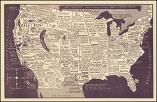
A fascinating artifact from the early era of American automobile travel, this Highway Map to California via San Diego was published in 1929 by the San Diego-California Club of the San Diego Chamber of Commerce. Engraved by the Sunset Engraving Co., it delineates the major national highways ending in San Diego, California, promising the "shortest, coolest, and all-year route to the Pacific Coast."
The 1920s, often referred to as the "Roaring Twenties," was a time of significant economic growth and widespread social change in the United States, which saw the rise of the automobile as a popular mode of transportation. The creation of this map underscores the importance of California, and more specifically San Diego, as a major destination in this emerging automobile culture.
The map displays a complex network of routes, reaching from as far east as New York and Florida, to as far north as Vancouver, British Columbia. These pathways include the Broadway of America, the Old Spanish Trail, and the Pacific Highway among others, elucidating the interconnectedness of the North American landscape. Moreover, the verso contains 22 highway strip maps, providing specific routes around the Southwest, further emphasizing the meticulous planning and detail invested in this piece.
The Highway Map to California via San Diego stands as a historical document that captures the essence of a specific moment in American history—a time of exploration and expansion, spurred by technological advances and the growing popularity of automobile travel. Through its intricate web of routes, it conveys the cultural significance of the burgeoning era of motor tourism, and of San Diego’s importance as a pivotal hub in this nationwide network.
![The Theatre of War in North America, with the Roads, and Tables, of the Superficial Contents, Distances, &c.a By and American [with] A Compendious Account of the British Colonies in North-America.](https://storage.googleapis.com/raremaps/img/small/81762.jpg)
![[ Coronado and San Diego ] Bird's Eye View of Coronado Beach, San Diego Bay and City of San Diego, Cal. in Distance. Coronado Beach Company. Capital - One Milion Dollars.](https://storage.googleapis.com/raremaps/img/small/94042.jpg)
![United States of America [with] The Course of the River St. Laurence from Lake Ontarion to Manicouagan Point](https://storage.googleapis.com/raremaps/img/small/71643.jpg)
![[Historical Map of Julian, California]](https://storage.googleapis.com/raremaps/img/small/94157.jpg)