|
||

|

|
|

|
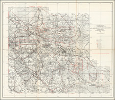
Rare separately issued pocket map of Los Angeles and Orange Counties, extending to parts of Riverside, San Bernardino, and Ventura Counties.
The map includes the names of a number of the Ranchos of Southern California, along with a table of distances to the principal points within Los Angeles and how to get there. A color coded key shows the 5 existing street car lines in operation.
Henry Rueger was one of the earliest publishers of wall maps and an atlas of the Los Angeles area. From about 1902 onward, he produced a number of the most detailed maps of Los Angeles, including a number of now quite rare wall maps. The present map would appear to be an updated version of Rueger's Map of Greater Los Angeles, published in 1902. as the size of the map is nearly identical. OCLC locates only 1 example of the map (LA Public Library). In 1905, issued a soils map of Los Angeles, a wall map of Los Angeles and a smaller city map of Los Angeles for Bekins in 1905.
The present map is Rueger's first map to reflect coverage outside of Los Angeles County in the title of the map. While the Library of Congress records the copyright of
Rueger's Pocket Map of Los Angeles and Orange Counties. . . on February 26, 1908, there are no examples noted in OCLC or any other public or private collection. The Bancroft collection of UC California includes a 1912 wall map map which sounds the most similar to the present map
:Rueger's township and sectional map of Los Angeles County and vicinity 1912,, which is described as 3 maps on a single sheet with rods and "Blue line print./ Includes inset of Santa Catalina Island and San Clemente Island./ "Compiled, published and copyrighted Nov. 1907 ..."/ "Attorney's
map showing names and boundaries of judicial townships."/ Also covers most of Orange County, and adjoining portions of Ventura and San Bernardino counties." However, the size of the maps are very different.
![Mexique par Th. Duvotenay…1842 [Republic of Texas]](https://storage.googleapis.com/raremaps/img/small/93713.jpg)
![(Southern California Aerial Photographs) [Collection of 9 Aerial Photographs of San Fernando Valley, Van Nuys, and Burbank]](https://storage.googleapis.com/raremaps/img/small/94783.jpg)
![Index Map of the Civil Code of California Designed and Executed By Curtis Lindley . . . [bound into] Revised Laws of the State of California; In Four Codes: Political, Civil, Civil Procedure and Penal . . .](https://storage.googleapis.com/raremaps/img/small/84298.jpg)