
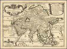
![(1st State) [ First Map of Asian Continent ] India Extrema XIX Nova Tabula By Sebastian Munster](https://storage.googleapis.com/raremaps/img/small/94610.jpg)


|
||

|

|
|

|
Nice full color example of the first separate map of Asia.
Munster based his maps on Ptolemy's Geographia, with significant updates and changes. Much of the information for this map of Asia came from the Travels of Marco Polo, written while Polo was in prison in 1298. This work told of Polo's travels with his father and uncle to China in 1275, and it had a immense impact on the conception of Asia held by Europeans through the sixteenth century.
The map contains many inaccuracies reflecting the lack of good, first-hand explorations of Asia. The Indian sub-continent is shown too small, whereas in contrast Southeast Asia is beginning to be depicted somewhat correctly. Ceylon, once shown as a very large island, is now more its proper size, though two islands are shown in the immediate area. The old misconception concerning Ceylon is still reflected on this map, however, for the ancient name for the island, "Taprobane," is applied to Sumatra, an island more in scale with Ptolemy's idea of Taprobane.
Munster extends the continent off the eastern edge of the map, so as not to commit on whether Asia was or was not connected with North America, despite his own map of America showing it as a separate land mass. Marco Polo's information was not all an improvement on Ptolemy. He introduced several geographic misconceptions, including one that put a 7,448 island archipelago off the coast of China, a misconception shown here by Munster with a scattering of islands and a legend giving their number. Besides its historic interest, this map has much visual appeal as well, with mole hill mountains, crenelated walls and towers to show cities, and Neptune and a huge sea monster in the ocean.
Sebastian Münster (1488-1552) was a cosmographer and professor of Hebrew who taught at Tübingen, Heidelberg, and Basel. He settled in the latter in 1529 and died there, of plague, in 1552. Münster made himself the center of a large network of scholars from whom he obtained geographic descriptions, maps, and directions.
As a young man, Münster joined the Franciscan order, in which he became a priest. He then studied geography at Tübingen, graduating in 1518. He moved to Basel, where he published a Hebrew grammar, one of the first books in Hebrew published in Germany. In 1521 Münster moved again, to Heidelberg, where he continued to publish Hebrew texts and the first German-produced books in Aramaic. After converting to Protestantism in 1529, he took over the chair of Hebrew at Basel, where he published his main Hebrew work, a two-volume Old Testament with a Latin translation.
Münster published his first known map, a map of Germany, in 1525. Three years later, he released a treatise on sundials. In 1540, he published Geographia universalis vetus et nova, an updated edition of Ptolemy’s Geographia. In addition to the Ptolemaic maps, Münster added 21 modern maps. One of Münster’s innovations was to include one map for each continent, a concept that would influence Ortelius and other early atlas makers. The Geographia was reprinted in 1542, 1545, and 1552.
He is best known for his Cosmographia universalis, first published in 1544 and released in at least 35 editions by 1628. It was the first German-language description of the world and contained 471 woodcuts and 26 maps over six volumes. Many of the maps were taken from the Geographia and modified over time. The Cosmographia was widely used in the sixteenth and seventeenth centuries. The text, woodcuts, and maps all influenced geographical thought for generations.
![I. a [Asia]](https://storage.googleapis.com/raremaps/img/small/93297.jpg)
![Asia [with inset:] Palestine or the Holy Land.](https://storage.googleapis.com/raremaps/img/small/93612.jpg)
![[ Ptolemy's Asia ] Asien nach Ptolemaeos](https://storage.googleapis.com/raremaps/img/small/97369.jpg)