|
||

|

|
|

|
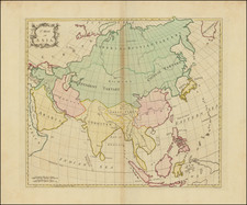
Fascinating map of Asia, drawn based upon the writings of Claudius Ptolemy, engraved by H. Fischer and published in Albert Forbiger's Handbuch der Alten Geographie . . .
The map presents a view of Asia as conceived by Claudius Ptolemy, the Greco-Roman geographer. The earliest known maps based upon Ptolemy's work date to the 14th Century. However, Ptolemy did not map the entire continent of Asia in a single map, making this depiction one of, if not the first attempt to depict Asia as a continent based upon Ptolemy.
During the 19th century, academic exploration of classical knowledge was prominent, particularly in German scholarship. Within this realm, Claudius Ptolemy's geographical theories were of significant interest. His work, the Geographia, had set foundational standards for mapping and geography that persisted through the Middle Ages and the Renaissance. In presenting a Ptolemaic perspective, this map provides a window into the historical views of European geography.
![[ Eastern Hemisphere Globe Gores. ] (Nova et integra universi Orbis descriptio)](https://storage.googleapis.com/raremaps/img/small/54480.jpg)
![[Asia] (Title in Greek-Turkish Hybrid)](https://storage.googleapis.com/raremaps/img/small/41721.jpg)