The item illustrated and described below is sold, but we
have another example in stock. To view the example which
is currently being offered for sale, click the
"View Details" button below.


|
||

|

|
|

|
Stock# 1722
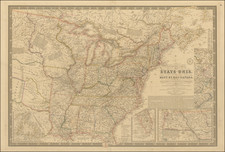
Description
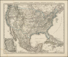
Excellent map of the US, with its borders in the West largely settled, although much of the West is still Territories. The transcontinental railroad is shown. Excellent detail throughout, including towns, roads, railroads, mountains, rivers, lakes, Indian Tribes, Forts, Passes, valleys, etc. Even includes elevations. A fine example of the excellent cartographic style which made German maps the best of the period.
![[ Promoting Emigration To The Czech Market ] Ceske Osady V Americe [ A Correct Map of the United States of America Showing Atchison, Topeka and Santa Fe R.R. and Connections ]](https://storage.googleapis.com/raremaps/img/small/101348.jpg)
![[Separately Published Example!] Map of the United States of America. Designed to illustrate the Geological Memoir of Wm. Maclure Esq.](https://storage.googleapis.com/raremaps/img/small/90048.jpg)