


|
||

|

|
|

|
Promoting the Southern Pacific To Czech Emigrants -- Hamburg American Line
Striking large format map of the United States, promoting the lines of the Atchiscon, Topeka & Santa Fe Railroad.
The title in Czech notes that it was issued with a publication entitled Czech Settlements in America (České osady v Americe).
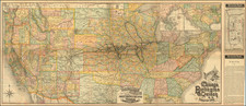
In 1886, Rand, McNally & Co. printed this remarkable map of the AT&SF and its connections, most notably those of the Southern Pacific Railroad and the Mexican Central Railroad. The map details the existing railroad lines, with emphasis on Kansas, Colorado, California, Arizona, New Mexico and Mexico, but with a number of proposed lines appearing in Texas. The lines reaching into Colorado reflect the recent boom in the mining regions of Southwest Colorado.
In Southern Calfiornia, the railroad is shown reaching San Diego, Santa Ana and San Pedro (not named), reflecting the beginning of Southern California's first major land boom.
This is one of several maps bearing the imprint of Josef Pastor, who at the time the primary agent in Prague for emigration to America for the Hamburg American Line, and employing detailed western railroad maps for promotional purposes.
Rarity
The map is extremely rare.
We note a single example in the collection of the Texas General Land Office.


![[Separately Published Example!] Map of the United States of America. Designed to illustrate the Geological Memoir of Wm. Maclure Esq.](https://storage.googleapis.com/raremaps/img/small/90048.jpg)