|
||

|

|
|

|
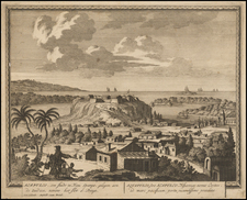
Striking regional map of Mexico, the Yucatan and part of Central America, extending to Honduras and Lake Nicaragua. Includes ornate scene, shwoing The Indians interacting with Cortes. The map was prepared to illustrate the account of Gil Gonzales Davila. In 1519, Davila led an expedition to explore the regions north of Panama City by Pedro Arias de Ávila, the first major Governor of the Spanish New World. Flawless example, in gorgeous color.
Pieter van der Aa (1659-1733) was a Dutch mapmaker and publisher who printed pirated editions of foreign bestsellers and illustrated books, but is best known for his voluminous output of maps and atlases. Van der Aa was born to a German stonecutter from Holstein. Interestingly, all three van der Aa sons came to be involved in the printing business. Hildebrand was a copper engraver and Boudewyn was a printer.