|
||

|

|
|

|
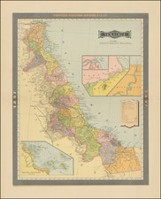
Fine Map of Mexico from the Cloppenburg Edition of the Mercator-Hondius Atlas Minor
Johannes Cloppenburg's map of Mexico originates from the famed Mercator-Hondius "Atlas Minor", first published in 1630.
The map, engraved in the style typical of the early work of Jodocus Hondius, offering a comprehensive view of Mexico, with a focus on topographical features including mountains, lakes, rivers, and cities. The topography is finely detailed, with individual mountain ranges, rivers, and lakes meticulously depicted, conveying the diverse terrain of the region. The sea surrounding the landmass is delicately engraved with a wave pattern, giving depth and dynamism to the marine area.
The city of Mexico, or Mexico City, stands out prominently, illustrated as it was during the time – situated on a lake. This depiction represents the Aztec capital, Tenochtitlan, which was built on Lake Texcoco and later became Mexico City.
Johannes Cloppenburg (sometimes Cloppenburgh; also H. Jan Evertsz and Johannes Everhardus) was a Dutch cartographer. Based in Amsterdam, he was active between roughly 1610 and 1644. He worked closely with the Hondius/Jansson firm and is credited with the 1630 edition of the Atlas Minor.

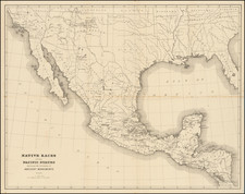
![(Texas) Denkschrift über eine Reise nach Nord-Mexiko, verbunden mit der Expedition des Obersten Donniphan, in den Jahren 1846 und 1847. Von Dr. A. Wislizenus. Aus dem Englischen übertragen von George M. von Ross. Mit einem wiffenschaftlichen Anhange und drei Karten. [Description of a voyage to northern Mexico connected with Colonel Doniphan's expedition in 1846 and 1847 By Dr. A. Wislizenus. Translated from the English by George M. von Ross. With a scholarly appendix and three maps.]](https://storage.googleapis.com/raremaps/img/small/88574.jpg)