|
||

|

|
|

|
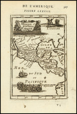
The Earliest Atlas Map of Tabasco, Mexico.
Scarce map of the State of Tabasco in Mexico, from Antonio Garcia y Cubas' monumental Atlas Geographico, Estadistico e Historico de la Republica Mexicana, the first atlas of the Mexican Republic.
Tabasco is on the Caribbean coast of Mexico, at the western base of the Yucatan. The map shows the historical configuration of the state, which has changed quite a bit over time. The old districts of Chontalpa, Sierra, Centro, and Macuspana are individually labeled and hand-colored. The town of San Juan Bautista is the largest in the state.
Antonio Garcia y Cubas was Mexico's first great map maker and his work is highly sought after. This map shows the various regions within Tabasco, including, towns, roads, rivers, etc. Only 300 examples of the atlas were reportedly printed and separate maps rarely appear on the market.
Rarity
The map is rare on the market; this is the first time we have had it.
Antonio García y Cubas (1832-1912) was a Mexican geographer, historian, writer, and cartographer. An orphan from a young age, Cubas attended the Colegio de San Gregorio and the Colegio de Ingenieros, where he earned a geography degree. In 1856, he became a member of the Sociedad Mexicana de Geografía y Estadística.
Cubas wrote several geographic works, including introductory courses to geography, historical atlases, and maps. He is best known for his Atlas Geográfico, Estadístico e Histórico de la República Mexicana (1857), Carta General de México (1863), and Diccionario Geográfico, Histórico y Biográfico de los Estados Unidos Mexicanos en cinco volúmenes, editados entre 1888 y 1891. He is also praised for his memoir, El Libro de mis Recuerdos (1905). Today, the best books published in anthropology and history in Mexico are given the Antonio García Cubas prize.

![(Mexican-Aztec Artwork) [Original pencil tracing of Aztec Calendar]](https://storage.googleapis.com/raremaps/img/small/102327.jpg)
![[ Earliest Obtainable Map of San Diego Bay ] Plan du Port De St. Diego en Californie. . . 1782 [with] Plan Du Port et du Departement de San Blas . . . 1777](https://storage.googleapis.com/raremaps/img/small/90982.jpg)
![Nouvelle Carte Du Mexique, Du Texas Et D'Une Partie Des Etats Limitrophes . . . 1840 [Proposed Railroads In Texas -- First Appearance of Arizona on a Printed Map]](https://storage.googleapis.com/raremaps/img/small/103480.jpg)