|
||

|

|
|

|
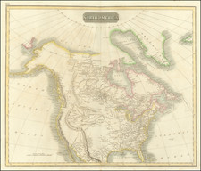
Rare variant of the first recorded appearance of Jedidiah Smith's Route on a printed map.
Rare and apparently unrecorded French edition of the map of the American Antiquarian Society's map of North America. Includes a color code listing the Esquimaux, Atapascas, Algonkin-Lenape, Iroquois, Cherokees, Creeks, Choctas & Chicasas, Sioux, Black Feet and Pawnee with color codes. A number of other tribes are named in the colored regions, and the Western Indians (are also named, but not colored). The map is attributed to Albert Gallatin, one of the more remarkable Americans of the first half of the 19th Century. This unrecorded French edition of the famous Gallatin map was originally published by the American Antiquarian Society in their Archaeologia Americana,1836. It was noted by Wheat, Cohen, and Howes as the best map of the West of its time. This edition is identical to the American version except for the addition of an area in the middle of the country with a double broken line which is referred to on the map thus: "Le Territoire definitivement attribue aux Indiens. Est indique par le double trail noir pointel." All other notes and place names are in English. Shows the California explorations by Jedidiah Strong Smith, many place names and notes. Calls the Great Basin the "Sandy Desert".
Gallatin was born in Geneva, Switzerland in 1761. After graduating from the University of Geneva he immigrated to Boston in 1780 and served in the Revolutionary Army. He later served as Secretary of the Treasury under Presidents Jefferson and James Madison. He held numerous official positions including a commissioner to the Treaty of Ghent, as the United States Envoy Extraordinary and Minister Plenipotentiary to France, the Minister Plenipotentiary to Great Britain, and president of the National Bank of New York. While we have handled the rare American edition of the map on 3 or 4 prior occasions, this is the first time we have ever seen the French edition.
![[ California Petroleum ] A Description of the Recently Discovered Petroleum Region in California. With a Report on the Same [with:] Map Representing Locality of The Ojai Ranch in Santa Barbara County, California, belonging to the California Petroleum Company 1865](https://storage.googleapis.com/raremaps/img/small/103844.jpg)
![[Vermont schoolgirl manuscript map of the United States by Lucy Hosford of Ely, VT]](https://storage.googleapis.com/raremaps/img/small/85583.jpg)
![[ Trans-Atlantic Cable ] Amerique Septentrionale avec l'indication des Principaux Courants marins d'Amerique en Europe](https://storage.googleapis.com/raremaps/img/small/98084.jpg)