|
||

|

|
|

|
A Unique East-West Orientation
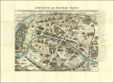
Fine old color example of Desnos' updated edition of Jaillot's large plan of Paris offers a unique east-west orientation, extending from Port de la Rapée to Cours la Reine-Ecole Militaire in the north, and from Belleville and Montmartre on the left to Ste Anne's Hospital and Petit-Montrouge-Chemin de Vaugirard on the right. Such orientation.
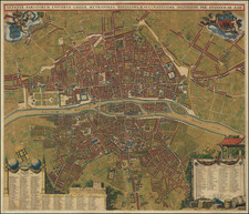
East-West orientations are quite unusual for the 18th century, with the map intended to present a more "ideal" view of the city within a circular format.
The map features extensive references, including tables listing streets, quays, crossroads, ports, squares, chapels, schools, parishes, and markets, with an additional table of new streets positioned below the main plan. This detailed referencing highlights the evolving urban landscape of Paris during this period, marking the city's expansion and development.
The craftsmanship involved in creating this map is evident in the beautiful, original coloring and the meticulous engraving. The map is a significant artifact of Parisian cartography, reflecting the artistic and technical expertise of Desnos, who served as the engineer-geographer and bookseller to the King of Denmark.
Additionally, this map includes a handwritten title on the first cloth folding panel.
Rarity
The map is quite rare. This is the the first example we have seen (1992-2024).
![[Paris World's Fair] Exposition Universelle de 1900 -- Plan General](https://storage.googleapis.com/raremaps/img/small/92123.jpg)
![[ Paris ] Vue generale des Palais De L'Exposition Universelle De 1878 . . .](https://storage.googleapis.com/raremaps/img/small/74482.jpg)