|
||

|

|
|

|
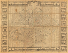
Highly detailed antique map of Paris with the names of the most important buildings in cartouches, published by Johannes De Ram in Amsterdam, circa 1685 to 1690.
According to Boutier, the map is in part based on the Jouvin de Rochefort plan of 1676. The map can be dated to around 1685 because Place des Victoires and Place Vendome are not yet shown, though Boutier suggests it was first published around 1690.
Boutier, 130A (translated from French):
"With Privilege of the Lords of the Estates of Holland & West-Friesland". Legend at the bottom in two monumental cartouches, on the left, “Demonstration of the Principal Streets”: the city (34 to 137), the city (26 to 42), the university (57 to 146); on the right, “Demonstration of the Principal Buildings”, the city (1 to 33), the city (1 to 25), the university (1 to 56). - Top left, arms of France; on the right, arms of Paris.
The plan reproduces quite closely the plan in one plate of Jouvin de Rochefort (n° 116) but represents in elevation monuments and buildings. Not featuring either Place des Victoires or Place Vendôme, it shows the topography of Paris around 1685.

![[ Paris ] Lutetiae Parisiorum Universae Galliae Metropolis Novissima & Accuratissima Delineatio per F. de Witt Cum Privilegio](https://storage.googleapis.com/raremaps/img/small/93387.jpg)