|
||

|

|
|

|
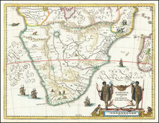
The Second Map of Southern Africa
Nice example of the Lorenz Fries map of the southern part of Africa, the second earliest map to focus on the southern part of the African Continent, first published in 1522.
This modern map of the southern part of Africa is a remarkable artifact, revealing as much about the mindset and the geographical understanding of the era as it does about the African continent itself. Based upon the 1513 map of the same region by Martin Waldseemüller, Fries's map is the second earliest map to focus exclusively on the southern part of the African continent.
Coastal Exploration and the Knowledge of the 15th and Early 16th Century
The European exploration of the African continent during the 15th and early 16th centuries was largely driven by the quest for maritime trade routes. Portugal's Henry the Navigator pioneered these explorations, sponsoring numerous voyages along Africa's west coast. By 1488, Bartholomew Dias had rounded the Cape of Good Hope, and in 1497-1498, Vasco da Gama successfully reached India by sailing around the southern tip of Africa.
Despite these extensive coastal explorations, the interior of Africa remained largely unknown to Europeans. This lack of knowledge is evident in Fries's map, where the coastal regions are densely populated with place names, while the interior remains largely blank, populated with symbolic illustrations of rivers, mountains, fauna, and kings.
The Interior Details
Among the most intriguing features of the interior in Fries's map are the sources of the Nile River, depicted as emanating from the Mountains of the Moon. This concept originated from ancient authors such as Ptolemy, and it continued to resonate with European geographers into the 16th century.
Three rulers are depicted in the interior: "Quilo Regmun," likely a reference to the legend of Prester John, an early Christian patriarch believed to rule a Christian nation lost amidst the Muslims and pagans in the Orient; "Hengi Zedaici," which may symbolize a local ruler or kingdom; and "Charagassa," whose identity is uncertain but might represent a misinterpretation of a local name or title. These illustrationsreflect European fantasies about exotic foreign rulers rather than historical realities.
Below the Mountains of the Moon, an area is titled "Haec Pars Aphricae Antiquuioribus Mansi? Incognita," translating roughly to "This part of Africa remained unknown to our ancestors." This Latin legend symbolizes the European acknowledgment of their ignorance about the African interior. The phrase "Subisamontibus sut Basili feiet Merguh: et est totum qnas desertium propter eos" seems to be a Latin corruption and its meaning remains unclear, the translation might be something like: "Below the mountains are [Bafili fei et Merguli], and it is almost entirely a wilderness because of them."
The Depiction of the South Atlantic
In the South Atlantic, the map features a Christian Monarch with a scepter and Portuguese Flag riding a sea creature. The legends "Christianissium Emanuelis Regis portu galliae metona" and "Hec insula habet incirantu ferme Anulia miliarium dives multum habet et leons/elephantes/camelos/et cetera animalia. incolrsunt Macometani" refer respectively to King Manuel I of Portugal and a rich island inhabited by Muslims. The reference to the Muslim island might be an attempt to depict a specific region in Africa or the Indian Ocean known to be inhabited predominantly by Muslim communities. During the 15th and early 16th centuries, trade between Europe and Asia brought Europeans into contact with various Muslim-ruled territories, including parts of East Africa, such as the Swahili Coast, and islands in the Indian Ocean, like the Maldives.
The association of the island with richness and exotic animals could symbolize the abundance of goods and natural resources available in these regions, which were highly sought after in Europe. The mention of "Macometani" or Muslims might be indicative of the growing awareness of Islam in African regions and perhaps an acknowledgment of the complex social and religious fabric of the continent.
The Mountains of the Moon
The present map contains several elements that would appear odd to the modern eye. The Mountains of the Moon (Mone Lune), depicted at center below the Equator, were believed for centuries to be the source of the Nile River. Ptolemy’s Geographia tells the story Diogenes, a Greek trader and merchant traveling in East Africa around 110 AD. Diogenes supposedly discovered the Mountains of the Moon, whose snowmelt fed two great lakes, which in turn fed the Nile. While this map shows a second-century legend, the story was still a viable geographic theory in the sixteenth century. The Mountains of the Moon remained on maps long into the eighteenth century and beyond.
Rulers, Real and Imaginary
The present map depicts four different rulers. Near the Equator to the east, a crowned, bearded ruler is labeled Quiola Regnum, likely referring to the area of Quiloa, now known as Kilwa Kisiwani, Tanzania. Kilwa Kisiwani was a major Swahili trading city that controlled Indian Ocean trade with Arabia, India, and China, especially between the thirteenth and sixteenth centuries, when Kilwa Kisiwani merchants traded gold and ivory for silver, perfumes, and Chinese porcelain. The city even minted its own currency between the eleventh and fourteenth centuries. After the Portuguese established a fort on Kilwa Kisiwani in the sixteenth century, the city began to decline.
Farther south near Mozambique (Moncabiqui), a crowned, bare-chested ruler is labeled Charagassa. Above the Tropic of Capricorn sits a third king, with robe and scepter, Hengi Zedaici.
Off the southeast coast, Emmanual, the most Christian King of Portugal (Manual I the Great and Fortunate, r. 1495-1521) sits astride a sea monster. This last scene is taken directly from Waldseemüller’s Carta Marina (1516).
Ptolemy’s Geographia in Renaissance Europe
The translation of Claudius Ptolemy’s Geographia from Greek into Latin for the first time in the late fourteenth and early fifteenth centuries spurred a wave of renewed interest and updated editions.
Ptolemy’s ideas had been absent from western European intellectual history for roughly a thousand years, although Arab scholars interacted with his ideas from the ninth century onward. In 1295, a Greek monk found a copy of Ptolemy in Constantinople; the emperor ordered a copy made and the Greek text began to circulate in eastern Europe. In 1393, a Byzantine diplomat brought a copy of the Geographia to Italy, where it was translated into Latin in 1406 and called the Cosmographia. The manuscript maps were first recorded in 1415. These manuscripts, of which there are over eighty extant today, are the descendants of Ptolemy’s work and a now-lost atlas consisting of a world map and 26 regional maps.
When Ptolemy’s work was re-introduced to Western scholarship, it proved radically influential for the understanding and appearance of maps. Ptolemy’s use of mathematics and astronomy to depict the world appealed to the intellectual climate of the Renaissance. Ptolemy employs the concept of a graticule, uses latitude and longitude, and orients his maps to the north—concepts we take for granted today.
The Geographia’s text is concerned with three main issues with regard to geography: the size and shape of the earth; map projection, i.e. how to represent the world’s curve proportionally on a plane surface; and the corruption of spatial data as it transfers from source to source. The text also contains instructions as to how to map the world on a globe or a plane surface, complete with the only set of geographic coordinates (8000 toponyms, 6400 with coordinates) to survive from the classical world.
Early printed editions of Ptolemy’s Geographia
Some of the most important, and the most numerous, early printed maps were in editions of Ptolemy’s Geographia (Cosmographia). From 1475 to 1650, there were more than forty new editions of the Geographia, which increasingly featured updates based on current knowledge, including recent voyages of discovery.
The text was first published in 1475 in Venice without the maps. An edition with the maps followed in 1477, printed in Bologna. These maps were another first—they were the first copperplate maps, in which an engraver scores copper, which is then inked and pressed. The Bologna edition included 25 of the original 26 regional maps (map XV was missing), as well as the world map.
A second edition with maps appeared in Rome in 1478. The third edition with maps was printed in Florence in 1482, the first to be printed in a vernacular language, Italian. It included 31 copperplate engraved maps, making it the first to augment the traditional 27 Ptolemaic maps with tabulae novellae, or modern maps. The modern maps included maps of Italy, Spain, and France.
The next edition to include the maps was the 1482 Ulm edition, which was the first atlas to be printed north of the Alps, as well as the first edition to use woodcut, not copperplate, printing. Copperplate engraving is an intaglio method; it cuts into the surface of the printing plane in order to create an impression when the engraved lines are inked. Woodcut engraving is a relief method; the surfaces to be inked are left standing, while the blank spaces are cut away.
Martin Waldseemüller separated his 1513 edition into two sections—one with the original maps and text, and the second with updates based on current knowledge of the world, including twenty modern maps. Fries followed this trend in his 1522 and 1525 editions, separating Ptolemy’s respected work from new knowledge and updated maps. He also added three more modern maps than Waldseemüller, but based on the other mapmaker’s work, for a total of 23. The plates for Fries' Ptolemy were then bought brothers Melchior and Gaspar Trechsel of Lyon, who published the 1535 edition from which this map comes.
This map is a testament to the importance of Ptolemy to early modern geography, but also to the ingenuity of that time. It is the early obtainable map of this region and one of the earliest maps to show the region in detail.
Lorenz (Laurent) Fries (ca. 1485-1532) was born in Mulhouse, Alsace. He studied medicine, apparently spending time at the universities of Pavia, Piacenza, Montpellier and Vienna. After completing his education, Fries worked as a physician in several places before settling in Strasbourg in about 1519. While in Strasbourg, Fries met the Strasbourg printer and publisher Johann Grüninger, an associate of the St. Dié group of scholars formed by, among others, Walter Lud, Matthias Ringmann and Martin Waldseemüller.
From 1520 to 1525, Fries worked with Grüninger as a cartographic editor, exploiting the corpus of material that Waldseemüller had created. Fries' first venture into mapmaking was in 1520, when he executed a reduction of Martin Waldseemüller's wall map of the world, first published in 1507. While it would appear that Fries was the editor of the map, credit is actually given in the title to Peter Apian. The map, Tipus Orbis Universalis Iuxta Ptolomei Cosmographi Traditionem Et Americ Vespucii Aliorque Lustrationes A Petro Apiano Leysnico Elucubrat. An.o Dni MDXX, was issued in Caius Julius Solinus' Enarrationes, edited by Camers, and published in Vienna in 1520.
Fries’ next project was a new edition of the Geographia of Claudius Ptolemy, which was published by Johann Grüninger in 1522. Fries evidently edited the maps, in most cases simply producing a reduction of the equivalent map from Waldseemüller's 1513 edition of the Geographie Opus Novissima, printed by Johann Schott. Fries also prepared three new maps for the Geographia, of Southeast Asia and the East Indies, China, and the world, but the geography of these derives from Waldseemüller's world map of 1507.
The 1522 edition of Fries' work is very rare, suggesting that the work was not commercially successful. In 1525, an improved edition was issued, with a re-edit of the text by Willibald Pirkheimer, from the notes of Regiomontanus (Johannes Müller von Königsberg).
After Grüninger's death in ca. 1531, the business was continued by his son Christoph, who seems to have sold the materials for the Ptolemy to two Lyon publishers, the brothers Melchior and Gaspar Trechsel, who published a joint edition in 1535, before Gaspar Trechsel published an edition in his own right in 1541.
![[Southern Africa] Tabula nova partis Africae](https://storage.googleapis.com/raremaps/img/small/103295.jpg)
![[With Photos of an Early Owner!] Troye's Map of the Transvaal or S.A. Republic](https://storage.googleapis.com/raremaps/img/small/87453.jpg)