|
||

|

|
|

|
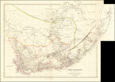
Finely executed 6 sheet map of the Transvaal or South African Republic, published in Winterthur, Switerland by Wurster, Randegger & Co.
First issued in 1892, the present example notes on the cover that it is a "Revised Edition 1896."
The map is accompanied by 5 black and white photos of what is likely its original owner, two showing him as an officer in South Africa and 3 showing what is likely him at his home on what looks like the coast of Scotland.
Rumsey notes:
. . . This map shows the Transvaal or Republic of South Africa, which was also known by the unofficial name of Republic of Transvaal. The Transvaal was in the 19th century an independent Boer state of southern Africa. Established in 1852 by the Treaty of Sand River, the Transvaal territory was incorporated as a republic in 1856. Annexed by the British in 1877, it was again independent from 1884 to 1900.
The ZAR (Zuid-Afrikaansche Republiek) was occupied a second time by the British troops in 1900, during the Second Boer War, before being officially dissolved in 1902 when the Treaty of Vereeniging was signed. In 1910, the old republic became one of the four new provinces of the dominion of the Union of South Africa.
For this map, the districts of Pretoria, Heidelberg, Middelburg, Ermelo, Wakkerstroom, Utrecht and Pietretief, as well as the southern part of Lydenburgh, and parts of Potchefstroom and Marico, were drawn from various surveys made available to the author by the Surveyor General of South Africa. Those of Waterberg, and parts of Rustenburg and Zoutpansberg, were prepared by the Surveyor General's Department from inspection plans, under the direction of government surveyors.
The author also used information from the maps and plans of surveyors Fred Jeppe and Kelsey Loveday, among others. As far as possible, the boundaries of land holdings have been fixed, with their names; but in the absence of reliable information, the map in this respect is somewhat incomplete. The significant differences between this map and those published previously are to be found in the north and northeast of the Republic. All means of communication are mentioned, and the gold fields are clearly indicated.
Troye was a surveyor, cartographer and consulting engineer, who compiled a number of important maps of the Transvaal and its gold fields.
His most important contribution to cartography was Troye's map of the Transvaal or S.A. Republic (1:500 000, on 6 sheets), lithographed in Switzerland and published in six colors in Pretoria. The map was the first topo-cadastral map of the Transvaal and by far the most complete, accurate and attractive map of the territory produced up to that time.
He used farm diagrams and inspectors' records in the surveyor-general's office to map farm boundaries and list farm names, while information was also obtained from F.H. Jeppe's* map of 1889.
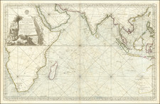
![[Southwestern Coast of Africa] Pas-Caart van Guinea en de Custen daer aen gelegen Van Cabo verde tot Cabo de Bona Esperanca](https://storage.googleapis.com/raremaps/img/small/46931.jpg)