|
||

|

|
|

|
Stock# 103068
Description
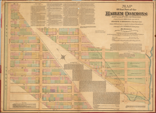
Gorgeous map of New York City, hand colored by wards.
From the true first edition of Gray's Atlas. Extends to Brooklyn, Hunter's Pt., Williamsburgh, Green Point, Jersey City and Hoboken. Extends north to include most of Central Park to about East 83rd. Shows streets, roads, rail lines, buildings, parks, wharfs, bridges, etc.
A fine map of the city.
Condition Description
Engraving on 19th-century wove paper. Original hand-coloring. Some very minor foxing.
O.W. Gray Biography
O. W. Gray was a publishing firm based in Philadelphia. Later, they published as O. W. Gray & Son. They published atlases in the late nineteenth century. Gray's National Atlas was one of the most successful commercial ventures of the 1870s and one of the last to employ hand coloring on maps.
![[Revolutionary War Plans of New York, Boston, Charleston, Delaware River to Philadelphia & Havana] Various Plans and Draughts of Cities, Towns, Harbours &c . . .](https://storage.googleapis.com/raremaps/img/small/83450.jpg)
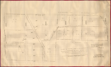
![[Hells Kitchen / Midtown West] Map of the Hermitage Farm and the Norton Estate Compiled From Authentic Data.](https://storage.googleapis.com/raremaps/img/small/61035.jpg)