|
||

|

|
|

|
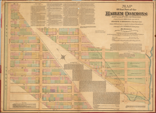
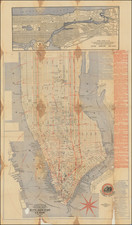
Rare Antique Map of Part of Harlem, New York City.
Superb large format, separately issued map of parts of the Upper East Side and Harlem in Manhattan, by one of New York's most fascinating mapmakers, John Bute Holmes.
This map shows a strip of land (in two sections) with the southern border proceeding northwest from 74th street and the East River to 86th Street and Central Park. The northern border extends from 74th Street and the East River to 96th Street and Park Avenue.
The so-called Harlem Commons extended northwest from the sawmill supposedly located around the present intersection of 74th Street and East End Avenue. It continued through the Upper East Side north into Harlem through what is now Central Park.
Provenance
This map was acquired as a part of a large collection of New York cadastral maps associated with the layer Ronald K. Brown, a Deed Commissioner operating in the late 19th and early 20th century with an office at 76 Nassau Street, New York - not far from Holmes' own office. Most of the maps in the collection, including the present map, bear Brown's stamp on the verso. The maps were passed to Dominic Anthony Trotta, a real estate agent working under Brown. Brown seems to have ceased business around 1919, but Trotta continued as a real estate agent, becoming a New York Tax Commissioner in 1934 under the Fiorello H. La Guardia administration. The maps remained with Trotta's heirs until our acquisition of the collection.
Publication History and Census
This map was created and published by John Bute Holmes in 1866. Three examples are recorded in the OCLC as being part of the institutional collections at Princeton University, the New York State Library, and the University of Wisconsin - Milwaukee. New York Public Library has an uncataloged example.
City Surveyor John Bute Holmes (ca.1820-1887) was a compelling figure, as much for his scandalous personal life, as for his ingenious maps.
The details of his early personal life are difficult to trace, partially as he constantly changed his version of his biography. At one point he claimed to have been born on the Island of Mauritius in 1822, and to have moved from there to Cork, Ireland; according to his account, he moved from Cork to the United States in 1838. He held the position of City Surveyor in New York in the 1860s through 1880s and eventually settled on a farm in New Jersey, where he died.
According to the cataloging of Lindsay Turley, of the Museum of the City of New York:
John Bute Holmes was married to at least four women during his life, sued by a fifth for "impeaching her chastity" as a result of "breach of promise of marriage," known to have lived with another "as husband and wife," and was reputed to have killed a policeman with whose wife he was involved. Some of these relationships appear to have overlapped, and most of the wives were unaware of the previous wives, even when the unions had been dissolved legally. It wasn't until Holmes's death in 1887 that the four legal (or at least to their knowledge) wives came face to face in an attempt to claim their inheritance. The dual nature of Holmes's maps strangely seems to reflect the duplicitous nature of Holmes's life...
A few different accounts in the New York Times attempt to sort it out, and briefly, this is what I've come away with:
- Wife # 1: Anna Maria Clear, married Cork Ireland 1838. Holmes left her in 1856, Anna filed for divorce in 1875. One daughter.
- Living as husband and wife: Ida Kerr, dates unknown.
- Wife #2: Hannah Wright Williamson (also his half-sister), marriage date unknown. Three children.
- Sued for breach of marriage promise: May Chamberlayne, 1874.
- Wife#3: Mary Sullivan Browning, marriage date unknown. One son.
- Wife#4: Katie Meadows, married ca. 1886.
See the MCNY blog entry on John Bute Holmes here: https://blog.mcny.org/2014/03/04/john-bute-holmes-surveyor-and-polygamist/
Holmes is thought to have produced a total of 21 maps of between the 1860s and the 1880s. We have not completed a total census of all map titles from Holmes' series, but we have handled over a dozen from one collection only.
"Farm Maps"
Although it is now hard to believe, Manhattan, as recently as the early 19th century, was largely covered in open farmland. As the city rapidly developed during the 19th century, all hints of its previous bucolic state fell away. In the 1860s, this transformation became a fascination for City Surveyor John Bute Holmes (about whom, more later).
Holmes began gathering old surveys and documents that related to Manhattan's previous land use and landowners, transposing new lot and street detail over the previous geography.
There was a long history of mapping Manhattan's farms, both during the actual agricultural era and thereafter. One of the greatest cartographic feats was Randel's Farm Maps which are reminiscent of Holmes' without the "modern" overlay. http://www.mcny.org/content/randel-farm-maps
![[ New York City View ] Buckley's New York Quadrille](https://storage.googleapis.com/raremaps/img/small/86578.jpg)