|
||

|

|
|

|
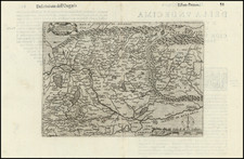
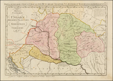
Detailed postal and general map of Hungary, published in about 1800 in Vienna.
The map shows administrative divisions and regional categorizations of certain areas. The text is in German and lists various "Kreise" (districts or circles) along with their respective locales and administrative units.
The map key identifies different regions situated "diesseits" (this side) and "jenseits" (the other side) of significant geographical markers like the Danube and the Theiss (Tisza) rivers, reflecting how territories were organized with reference to these water bodies. These terms help to locate the districts geographically in relation to the rivers. Each entry references different groups, areas, or administrative divisions, like "Preßburg," "Trentschiner," "Neusohler," and others, which are likely historical or old German names for places within Hungary or along its borders.
The map also notes other specific geographical and administrative details, such as military borders and various Hungarian counties.
The map highlights the complexity of Hungary's historical administrative divisions and reflects the period's geographical and political landscape.
![[Danube River Survey] Alap's Vizhelyezeti Térképe Buda és Pest szabad király fő városainak, mellyet á N.M.M.K. Helytartó Tanács kegyes Engedelme mellett á magyar országi Tekintetes Epito fő Kormány . . . Tagjainak alarzatos tisztelettel ajánl Vörös László á kiadó és országos dunamérési hiteles földmérő. Budan MDCCCXXXIII.](https://storage.googleapis.com/raremaps/img/small/57469.jpg)