|
||

|

|
|

|
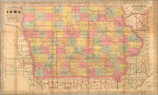
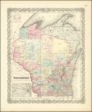
A rare antique map of the Midwest, from Rogers & Johnston's Atlas of the United States, one of the most attractive American atlases of the 19th century. This atlas was an unusual collaboration between an American, Englishman, and Scot. The map is a fragment of Rogers & Johnston's excellent and equally rare wall map. The map names counties, towns, rivers, Indian tribes, and more. The evolution of the Rogers & Johnston work extends to 1873 when a modified example of the wall map was issued in Atlas form, first as the People's Pictorial Atlas by J. David Williams and later as the Jones Historical Atlas, two of the rarer and more interesting late 19th-century American works. An important rarity for map collectors of this region.
This portrays a collection of northern states which had recently been admitted into the Union. Iowa was admitted one year prior to the publication of this map, making this one of the earliest maps to show it as a state. Areas of surrounding states are shown, as is the Minnesota territory which would gain statehood the following year, and the Nebraska territory which would gain statehood a decade later.
Proposed Pacific Railway Routes are shown overprinted in purple.
![[ Superior, Wisconsin ] The Next Great City Watch Us Grow Superior](https://storage.googleapis.com/raremaps/img/small/99914.jpg)