|
||

|

|
|

|
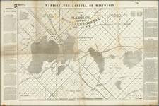
Rare separately published map of Superior, Wisconsin, showing the town during the boom times of the first decade of the 20th Century.
Published by local real estate agents Heimbaugh & Spring, the map promotes the growing infrastructure investment in Superior ($51 Million!), identifying major new projects by US Steel, The Soo Line, Wisconsin Central Railway, Arrow Line Electric Railway, Duluth, Missabe & Northern Railway, etc.
Superior Wisconsin
Superior, Wisconsin underwent significant transformations in the first decade of the 20th century, a period marked by industrial expansion and urban development.
As the 20th century dawned, Superior's strategic location at a key juncture of rail and lake transportation networks became increasingly vital. The city's economy and population were bolstered by the burgeoning iron ore industry in the nearby Mesabi Range. This era was characterized by the expansion of the steel industry, which found in Superior a critical point for shipping iron ore.
The most notable industrial development during this period was the establishment of massive ore docks by U.S. Steel, formed in 1901. These docks, among the largest in the world, were a testament to Superior's importance in the iron ore trade. The presence of U.S. Steel significantly reshaped the city's economic landscape, creating jobs and attracting a diverse workforce.
This influx of labor brought a wave of European immigrants, adding to the city's cultural fabric. The population growth led to urban expansion, with new neighborhoods and infrastructure developing to accommodate the growing community. The city also saw the rise of labor movements and unions, reflective of the increasing awareness of workers' rights in the industrial landscape.
Rarity
We were unable to find another example in OCLC or any other reference work.